Feed
%20(1).avif)

%20(1).avif)
%20(1).avif)
%20(1).avif)
.avif)
%20(1).avif)
%20(1).avif)
%20(1).avif)
%20(1).avif)
Latest Podcasts
Around the Movement
.avif)
An HOA president came to one of our Local Conversation meetings this summer with a problem that got our group excited. She already had city approval for a traffic-calming project on her suburban neighborhood street in east Fayetteville, Arkansas. Thirty feet curb to curb, no parking, long sightlines, and drivers treating it as a place to zoom through. She had done the paperwork, but not the work itself, and she had no template for how. She was nervous about it, reasonably so. She wanted the thing to work and she wanted it to look good.
That turns out to be the common case here. According to the City of Fayetteville, there are more than 30 approved tactical urbanism projects sitting at City Hall. This means somebody walked each one through the city, got the sign-off, and then never got to actually doing the work. Thirty-plus permission slips just waiting on volunteers! You can imagine how our Local Conversation reacted to that. Fayetteville's mobility coordinator, who is genuinely good at this and friendly with our LC, made the introduction to the HOA.
So this past weekend, Fayetteville Strong and the HOA built it. Over a dozen of us turned out on a hot Arkansas Saturday morning, some Local Conversation members, some neighbors. We painted striped bump-outs to pinch the entry (now ~17 feet), two planters with reflective tape, flexible delineator posts, and adhesive ground reflectors. It is nothing fancy, but it helps. The street now tells drivers what it is, which is a neighborhood street, and they slow down accordingly. As we worked, I did get a chuckle watching cars come around the corner too fast and seeing the nose dip as the driver tapped the brakes when they saw our setup.
There are two things I wanted to mention that surprised me.
The first was the gratitude, and how much of it there was. People stopped on their walks or stopped their cars to thank us. Even the mailman pulled his truck over, said thank you, and told us the neighborhood “really needed” this. We got some eye rolls, too, mostly from drivers in nice, luxury cars who had just lost their speedy route through. But the "thank you" crowd outnumbered the eye rolls by a mile.
The second surprised me more. A good number of the HOA volunteers had no idea who Fayetteville Strong was. So we told them while we worked, and those were the most productive conversations with Fayetteville residents I have had about this movement all year.
I have been chewing on that all weekend. Anyone can show up to a city meeting and complain. I do it regularly and I intend to keep doing it, but let us be honest about the price: a few minutes and the adrenaline of speaking in public. Sweat equity is a different currency. It costs a Saturday morning, a sunburn, and a willingness to do manual labor in public on a street that is not yours. It is clear to me that neighbors can tell the difference immediately. I would bet staff and elected officials can, too. Do this once and you stop being the group that objects and become the group that delivers. There is no way to write your way into that, and no way to get there in three minutes at a podium. You get there by showing up and doing the work when a neighborhood asks.
My advice from this experience: go find the people in your city who are already asking for help. Somebody has a street they have given up on, and a folder somewhere with the approvals already in it. Do the next smallest thing that makes their place a little stronger and a little more cared for. You might be surprised by the allies you’ll make along the way.
.avif)
%20(1).avif)
Houston by all means has traits of a world-class city. Our cuisine is on Michelin’s radar, we are one of the most diverse cities in the United States, and the region is still growing. But we’re still behind other world-class cities on transit. Our public transportation system lacks the fleet to service a region with over two million people and a landmass roughly three times the size of Chicago.
Despite the remarkable changes in 2015 to our bus system, Houston’s overwhelming freeways and wide stroads encourage, if not mandate, people to get around by car. This auto-dependent system is financially unsustainable for the city and deadly for the brave Houstonians who traverse their city by anything but a car.
Before we get much further, full disclosure: I was not born in Houston. I’m actually from McAllen, Texas, and spent a few years in San Antonio before moving to the Houston area — I lived in a suburb before moving within city limits. Despite being a foreigner, Houston took me in and I feel like an adopted Houstonian, which is a shared experience for so many other adopted Houstonians, too. That's why I’m writing about this place that I fight for every day.
As much as I love the Bayou City, though, we're dramatically behind our world-class peers, and now there’s research to prove it. Transportation for America released their “World-Class American Transit” report showing the level of investment American cities need to catch up to even the most basic global communities. World-class cities like London, Barcelona, Hong-Kong, Montreal, and Rio de Janeiro average about 133 transit vehicles per 100,000 residents. The average in the United States is a middling 27. Houston is an unfortunate exemplar of this trend with an average of 16 vehicles per 100,000 residents.
To get to “world-class American transit,” American cities need to spend big on buses and trains. Not as much as we are projected to spend on highways, but it’s still a lot. A world-class Houston, for instance, would need 5,012 vehicles comprising 4,733 buses and 278 train cars. That’s roughly a 435% increase in our fleet size (current as of 2023 per Transportation for America).
While this may read like another browbeating of Americans for not investing in public transportation, it’s not — thanks to METRO’s incredible experiment for the World Cup.
For one month during the World Cup, the City of Houston (a host city in the incredible Canada-U.S.-Mexico contest) improved its public transit. Frequency and service for Houston’s public transit pre-World Cup depended on routes for the most part, with most of our transit running less frequently in the evening (roughly past 8:00 p.m.). The bus system, for example, has high-frequency (15-minute interval), medium-frequency (15–30-minute interval), or low-frequency (30–60-minute interval) routes. Our light rail Red Line (which includes the stadium that hosted the World Cup games) ran six-minute intervals but only until early evening, and the other Green and Purple Lines normally ran 18-minute intervals.
With the World Cup upgrades, we saw an incredible experiment. Approximately 10 bus routes serving downtown and other popular areas received frequency and service upgrades, including late-night bus service. The park-and-ride system connecting Houston’s suburbs to its urban core ran every 30 minutes, seven days a week, until midnight. And our light rail lines saw frequency upgrades (with the Red Line running every six minutes and the Green and Purple Lines running every 12 minutes), added capacity with more train cars, and late-night service.
This summer gave Houstonians a glimpse into a Strong Towns vision for public transit. There’s plenty of research on the benefits of world-class transit, like housing affordability, infrastructure cost savings, and more tax dollars from connected communities. While this research may entice advocates to demand bigger and better transportation, Strong Towns rejects this “build it and they will come” approach; that thinking gave us massive highways and killer stroads. Instead, transit is a wealth accelerator that connects productive communities to one another and scales to the level of productivity. We can’t afford high-speed rail in Houston, so let’s just make our buses run faster and get people from great neighborhoods like Montrose and East Downtown to one another.
I’ll be the first to admit that I normally don’t ride public transportation in Houston. I drive to most of my events, not because I choose to, but because Houston’s highways and stroads give me no other option. When the World Cup came to Houston, however, I got to experience world-class Houston transit and loved it. I’ve been to Japan, Chicago, and other areas with high-frequency and reliable transit and I always wanted that for Houston. In one month, I took the bus more often, used the light rail to go see friends, and even joined in on an all-night transit crawl, which was only possible because of the World Cup upgrades.
Houston connected existing, productive communities to one another using a system that's already in place rather than a top-down grand scheme. We took our 2015 reimagined network and boosted frequency and service hours. Ferrying international tourists and residents didn’t require another reimagining of the system; we just upgraded frequency and extended service hours. While we created two new routes just for the World Cup, the majority of improvements just added barbecued meat to a good set of bones.
And the best part? We kind of just…did it. The city planned these service upgrades, for sure, but they didn’t drag this out like most transportation projects. Which is why Houston’s experimental approach deserves praise: it’s another example of Strong Towns principles in action. Cities often spend years planning transit improvements by debating projections, calculating costs, determining routes, etc., and there’s still a chance the entire project fails. Rather than deliberate, Houston simply tested out better transit.
Now that the World Cup tournament is over, Houston’s public transportation system goes back to normal. But should it? If Houstonians enjoyed getting a taste of world-class transit, then the city should start a conversation on how to keep these changes for the long term. If there were complaints, then study them and learn for the next time Houston wants to improve its public transportation. That’s the best part of the Houstonian experiment: we have the flexibility to go back to the drawing board if there’s problems and iterate to the next level of intensity if the experiment worked.
Houston lived up to its world-class potential this summer. In my humble opinion, the experiment was a success. Now let’s get to work on the next level of investment in our transportation system. That starts with keeping the World Cup service upgrades.
.avif)
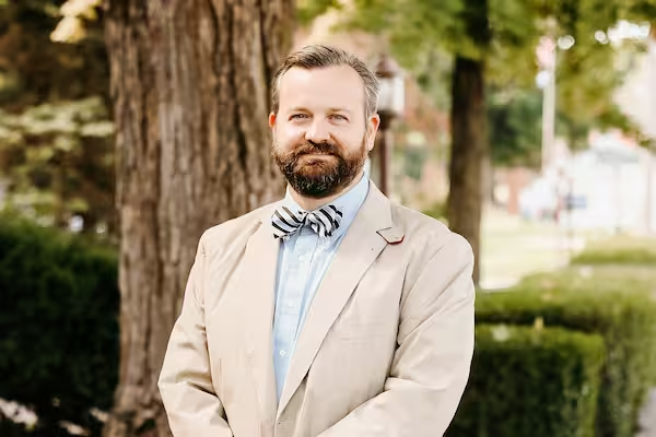
When Strong Towns member Gregory Guertin began updating the comprehensive plan for Smithfield, Rhode Island, he wasn't worried about writing the document. He was worried about asking the wrong question.
Like planning departments across the country, Smithfield could have followed a familiar script for public engagement. They could have started by sending out flyers for a weeknight meeting at city hall inviting residents to share what they want to see over the next 20 years. When a handful of residents arrive and sign in at the meeting, they are handed a stack of sticky dots or notecards. After a presentation forecasting the future of their community, the audience is then asked to use their dots or notecards to share their thoughts.
Gregory had seen this pattern play out in surrounding communities and he knew exactly what would happen. The meeting would produce a list of projects, priorities, and competing interests. It would also miss something essential.
It wouldn't explain why people love Smithfield.
For Gregory, that mattered.
As Smithfield's Director of Planning & Economic Development, and as someone who grew up there, with both his and his wife's families deeply rooted in the community, this wasn't simply another planning exercise. Smithfield, founded in 1730, is a place with a long memory. Its identity isn't found in zoning districts, future land use maps, or transportation plans. It's found in the stories people tell about growing up there, raising families there, and caring for the town across generations.
Gregory believed the town's future should begin there.
Strong Towns was invited to share Strong Towns 101 at the Comprehensive Plan Kick-Off Meeting, and Gregory had shared with me in advance the questions he was going to ask his community. When I started my talk, I shared the innovative approach Smithfield was taking to this process. Gregory didn't feel that way about it. He wasn't trying to be clever. He was trying to make sure the plan started somewhere deeper than preconceived solutions or the usual arguments over what should get built next. Smithfield carries a lot of history. It felt right to start with what people already treasure and let everything else grow from there.
He realized that a planning process for a town founded nearly 300 years ago shouldn't begin by asking people what they wanted built next. It should begin by asking what was already worth preserving.
So Gregory asked a different question. Instead of asking residents what they wanted, he invited them to tell a story: "Tell us about a moment, place, or experience in Smithfield that shaped how you feel about this town."
It was a simple question, and it completely changed the conversation.
Neighbors who might never have spoken at a traditional public hearing began sharing memories of favorite places, family traditions, everyday routines, and experiences that made Smithfield feel like home. Those stories uncovered something no survey or dot exercise ever could. Beneath dozens of individual memories were values the community already held in common: community, strong schools, open space, and the distinct character of Smithfield's villages.
Then came the harder part.
Working together, each table turned those values into principles. Then Gregory asked the question that mattered most: when a town can't have everything, what should it lean toward?
The answers surprised him. Nearly every table arrived at the same place. Money.
How do you support great schools while respecting what taxpayers can reasonably afford? How do you preserve open space while recognizing the pressures of growth? How do you protect village character without pretending difficult tradeoffs don't exist?
One table distilled its thinking into a simple truth: "Once it's gone, it is gone forever."
Another table captured an idea Gregory recognized immediately from the Strong Towns presentation earlier that evening: "Start little, takes time."
He even noticed another familiar phrase appear in the worksheets.
Someone had written "stroads," carefully placed in quotation marks, as if trying out a new word for the first time.
Those weren't policy recommendations. They were signs that something deeper had happened.
Residents weren't simply reacting to proposals. They were beginning to develop a shared language for thinking about their community and the difficult choices that lie ahead. The conversation had shifted from debating projects to discovering the values that should guide every future decision.
The comprehensive plan that emerges from this process will almost certainly look different from the one it replaces. More importantly, it will be rooted in something deeper than policy recommendations. It will reflect the lived experiences, shared values, and long-term stewardship of the people who call Smithfield home.
That's what a Strong Towns approach looks like in practice. It can't be handed to a community as a blueprint. It can't be prescribed as a one-size-fits-all solution. The Strong Towns approach is about helping local leaders find the confidence to ask better questions and create the conditions for their communities to shape their own future.
Gregory didn't set out to write a different comprehensive plan. He set out to help Smithfield discover what it already knew about itself.
Smithfield is still early in this process. The document itself, its zoning districts, its land use maps, its transportation plans, hasn't been written yet. But the foundation has. It's sitting on worksheets full of stories about villages, schools, open space, and what people are willing to give up to protect them. A town that starts there, with what it already knows about itself, is giving itself the best chance to get the rest right.

Recently, The Observer ran a headline: “Commissioner calls Manatee County ‘poor’ during workshop sessions.”
I said it on purpose because I want people to understand what we’re actually dealing with in Manatee County, Florida, not the press-release version of our finances, but the real version. When you look at what we’re obligated to pay, what we’re continuing to build, and what we’re failing to set aside for the future, “poor” is not a dramatic exaggeration. It’s an honest description of our current, and more importantly future, trajectory.
Let me explain how I got there.
The Strong Towns Finance Decoder Summit
I was invited to participate in a two-day work session with Strong Towns, an organization I’ve followed closely for years and genuinely believe in. In fact, when I became Chair in 2025, I handed all our commissioners the first Strong Towns book to help start better conversations about how cities and counties grow, spend, and plan. This work session was conveniently right after our first round of budget meetings (June 8–10).
Strong Towns pulled together a small group of 15 people. Charles Marohn (who runs the organization) was there with some of their staff. The rest of the room was a mix of people who live in this world every day: real estate tech industry, a professor, community activists running local Strong Towns conversations in places like Chicago and Albuquerque, and three elected officials (a councilwoman from Colorado, a mayor from Minnesota, and me).
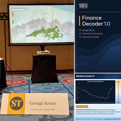
The focus of the session was their “Financial Decoder”; a tool built to help municipalities and counties understand their real financial position. Not the political version. The real one: what we owe, what we’re taking on, what’s sustainable, and what isn’t. For two full days, we did intense presentations, discussions, and problem-solving to sharpen the tool so communities can better see shortfalls coming before it’s too late.
The timing felt almost ironic. Everything we were discussing in that room maps perfectly to what Manatee County (and honestly most counties) are dealing with right now. After COVID, federal and state dollars flowed in fast. Departments expanded. Projects moved. Assets got built. Then the extra money dried up. Now we’re left with bigger systems to run and maintain but fewer outside dollars to help carry the load. Sound familiar?
To contribute to the work session, I ran Manatee County through the Financial Decoder myself. That meant pulling every single Comprehensive Annual Financial Report (CAFR) going back to 2009 and entering the data so we could see the long-term trend lines clearly. The output is a set of charts that make it hard to hide from reality.
What the Charts Actually Show
Let’s start with our net financial position.
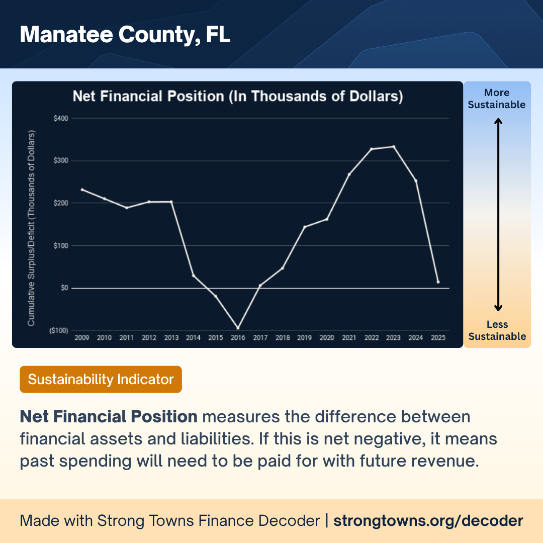
Net financial position is the difference between our financial assets and our liabilities. When it goes negative, past spending has to be paid for with future revenue. You can see that after a COVID-era spike, driven by stimulus and federal dollars flowing in, the line has dropped hard and is approaching zero. That is not a good direction.
The second chart shows interest-to-total revenues, which measures how much of our annual revenue goes toward interest payments on debt. When this rises, it limits future choices and begins crowding out basic services.
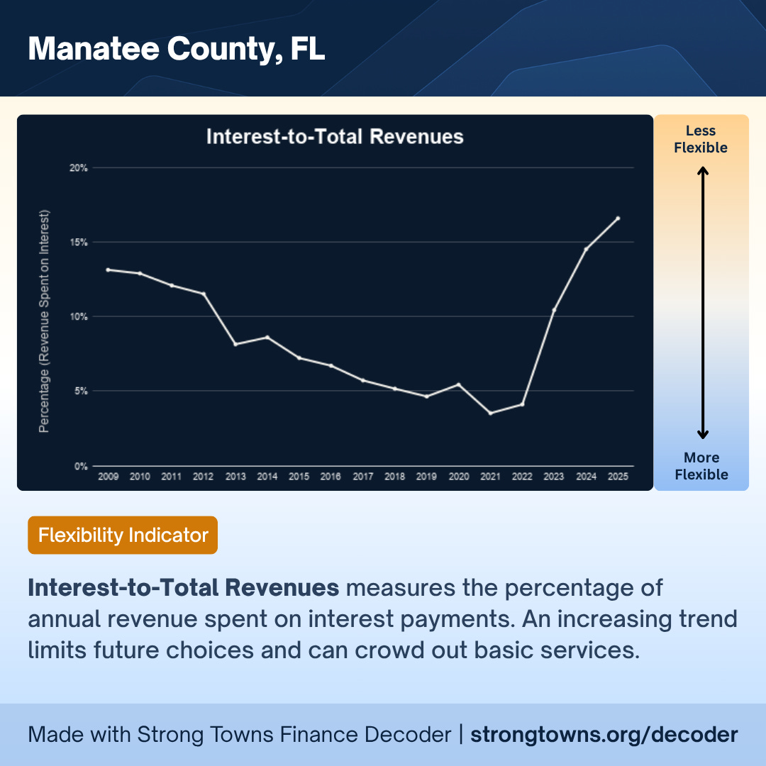
After years of improvement, the line turned sharply upward starting in 2021 as we bonded more for infrastructure to catch up with the inflow of population. Debt service is now our second-largest budget line item. Second only to the sheriff.
The third chart shows government transfers as a share of total revenue. Basically, how reliant we’ve become on outside funding from the state and federal government.
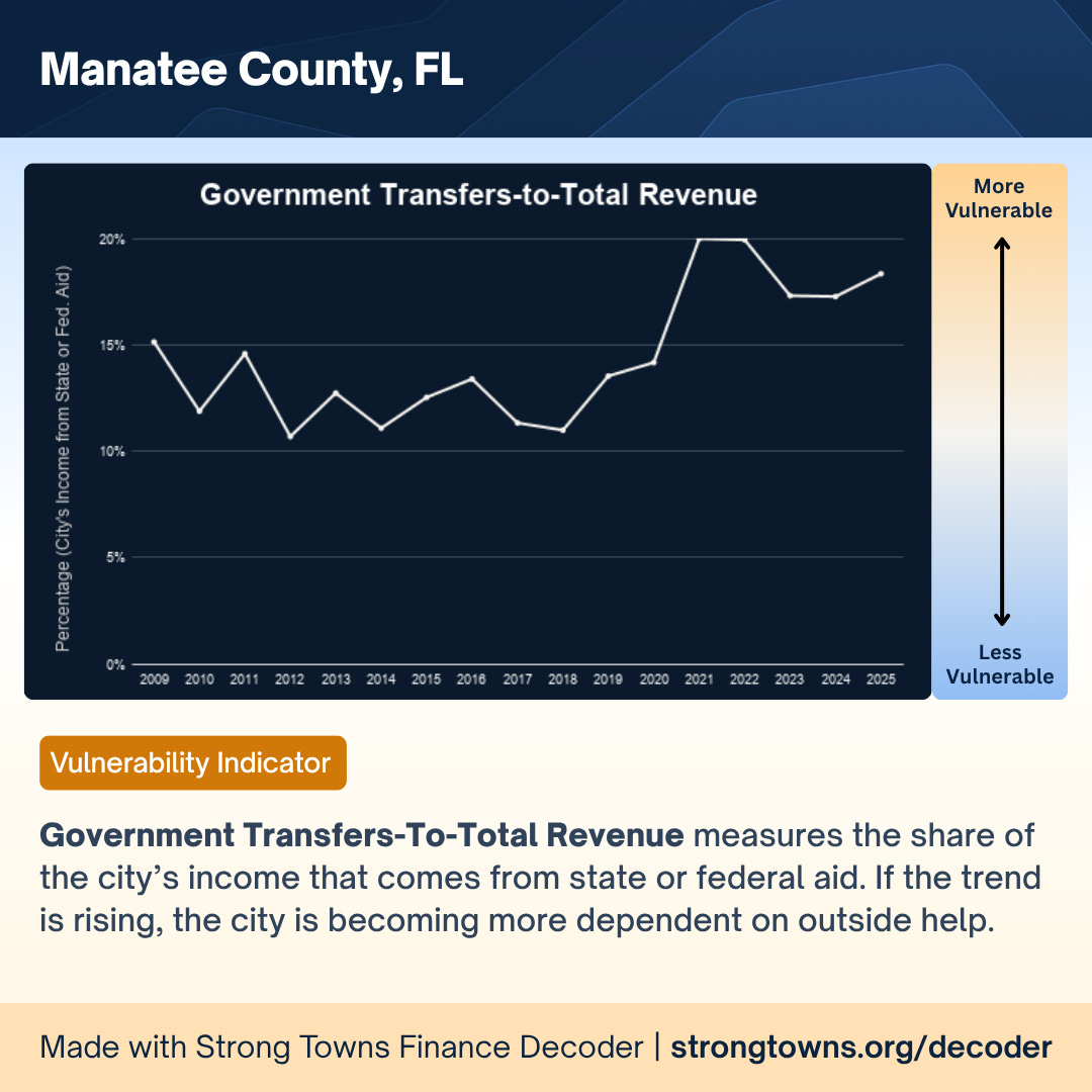
You can see the reliance climbing, particularly post-COVID. The problem: once those appropriations slow down or stop it will create holes in projects that assumed the money would always be there. And Tallahassee is already signaling tighter budgets and projected shortfalls at the state level in the coming years. This isn’t hypothetical.
The final chart brings it all together: total assets-to-total liabilities.
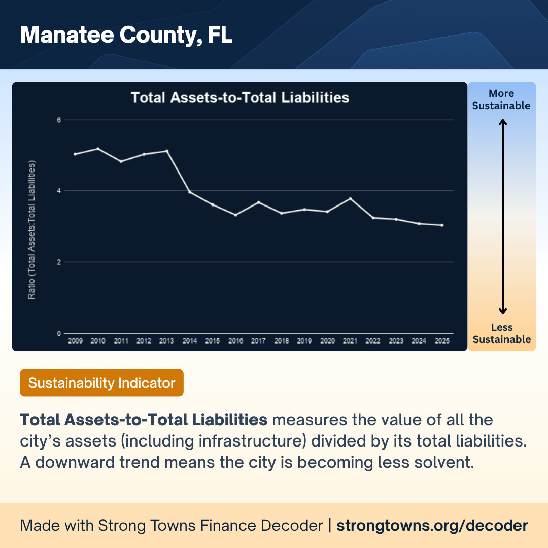
A downward trend here means the county is becoming less solvent over time. Our ratio has been in near-continuous decline since 2013. It has not reversed. The chart continuously goes the wrong way and the trend looks to continue.
The Reserve Cliff
Now let’s get specific to the Manatee County budget sessions for fiscal year 2027, because this is where the word “poor” becomes clearer.
The most immediate red flag is our reserves. Our county’s reserve policy recommends we maintain 20% of the general fund balance in reserves. Last year (FY26), the reserve was adopted at $109.3 million. This year (FY27), we’re being told our available reserve for cash balance is only $39.2 million, a drop of more than $70 million.
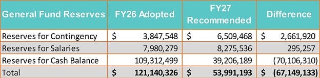
Based on the policy target, our reserves should be $111.7 million this year. We’re sitting at roughly $39.2 million. That means we are approximately $72.5 million short of our own policy requirement. Sitting at about 7% when the policy says 20%.
That is not a small miss. Those reserves are the cushion that keeps services running when the economy turns. And Manatee County is cyclical. We’re heavily reliant on construction, tourism, and service industries. When the economy slows, those slow and revenue can drop fast. Reserves are what keeps the lights on (sometimes literally) when the bottom falls out.
Reserves also aren’t just a nice-to-have. They’re not meant to be treated like a spare checking account. Once reserve dollars are gone, they’re gone. And if you spend reserves on recurring services, those dollars don’t create an asset you can point to later. You just have fewer reserves and the same ongoing service expectations.
What’s especially frustrating is that holding reserves is one of the few things that’s actually easy to maintain once you do it. It’s not like a new program that requires fresh annual funding forever. If you keep reserves at the proper level and avoid tapping them for day-to-day spending, you’re not constantly scrambling to “find” reserve money each year. But we haven’t done that, and now we’re in a deep hole.
If we stay on the current path, we’re heading toward a situation where reserves go $0 in another year. But “a sustained decline in general funds reserves” is a key factor in our credit rating (presently Moody’s: Aaa; Fitch: AAA) and a drop in these ratings will negatively affect our ability to, and our cost of, borrowing in emergencies. That’s why I’m sounding the alarm now, not later.
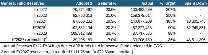
The reality is that we’ve simply been spending down reserves to cover non-emergency obligations. This is partly a result of recent millage cuts. Since 2021 we’ve lowered the millage rate by 0.70, a reduction of more than 10% across five tax cycles. The cumulative impact of those cuts is roughly $116 million less in property tax collections. That number is larger than the reserve shortfall we’re staring at.
We made up for reduced taxes by supplementing operating costs with our rainy day fund. And now the rainy day fund is nearly empty right as it’s getting cloudy.
In spite of what the State CFO may say on his campaign roadshow, Manatee County has not overspent $112 million in tax dollars. In fact, we’ve done what they want and went to the rollback over time to the detriment of our budget. The county portion of my tax bill has only increased $114 total over five years, or 0.016% of the appraiser’s market value of my home.
Through this analysis, however, I do agree that we’ve overspent since COVID. But that has come from excess spending of our healthy reserves and shortsighted capital project investments with non-recurring appropriations leaving us with increased future liabilities.
The Maintenance Cliff
Then we get to the conversation nobody wants to have in a county that keeps building new roads: can we actually afford to build more if we cannot maintain what we already have?
Manatee County has about 3,600 lane miles (roughly 1,538 center lane miles — the length of roads regardless of number of lanes). A straight-line estimate puts road maintenance at roughly $17,500 per center lane mile per year, or about $26.9 million annually just to maintain existing roads. The ones we already have. Not anything new.
In theory, gas taxes should cover most of that. We collect approximately $25 million in gas tax revenue. But last year we only spent about $19 million on maintenance. That means we underfunded road maintenance by roughly $8 million (about 30% of the maintenance that “should” have happened did not happen). And with roads, deferred maintenance doesn’t stay flat. It gets worse. It compounds. It gets more expensive.
And that’s before we add a single new lane mile.
We currently have over 35 miles of new roads under construction. When those come online, they will add roughly $600,000 per year in new maintenance obligations on top of the $8 million per year gap we’re already carrying.
People want those roads (our total transportation projects in the capital improvement plan are about $1.6 billion in future assets-turn-liabilities). I get it. But the question isn’t whether they want them or need them. The real question is where will the long-term maintenance money come from before we obligate future residents to additional unfunded burdens?
So Where Will We Make This Up?
The county’s gross budget this year is about $2.67 billion. That sounds enormous. But gross budget is deceptive as it includes internal transfers between departments, multiple reserve categories (impact fees, landfill, and more), state and federal appropriations, gas taxes, tourist development taxes, capital projects, and over a billion dollars tied to utilities (an enterprise fund that is almost entirely outside the property tax conversation people are actually having).
When you strip it down to what most people mean when they say “the county budget,” the operating budget is closer to about $500 million. And within that, the constraints are tighter than most residents realize.
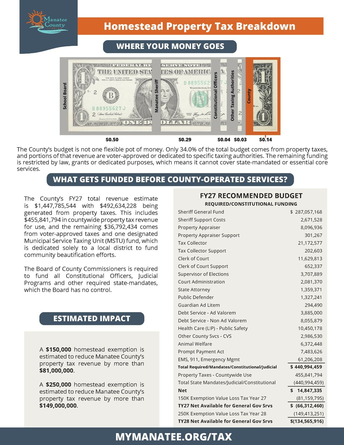
During budget week, we went through, in detail, exactly how much of our general operating fund is essentially required or state-mandated spending. That includes the sheriff (by far the largest share at over $287 million), the other constitutional officers, court-related obligations, contractual debt service, mandatory EMS and 911 emergency management, and healthcare-related costs. We don’t get to wave a wand and make those go away. But we can nominally lower the amount we allocate to them.
The total required/mandated spending comes to roughly $441 million. Our total property tax revenue countywide, net of referendum millages for children services and environmental lands, is approximately $456 million. Once those mandatory obligations are paid, according to our CFO, we have roughly $15 million left for everything else — parks, libraries, veteran services, transit, boat ramps, road maintenance, and every department residents interact with on a daily basis.
To really put the financial problem into focus: if we cut every single non-mandated service (all of them), without adjusting funding for mandated services, we’d free up that $15 million. Even if we put all $15 million into reserves, we’d still only get to around $55 million in reserves, roughly half of what our policy recommends.
That’s why I said the situation is serious. The math simply doesn’t work without hard decisions.
The Math That Defines the Problem
If you combine the reserve shortfall and the maintenance reality, you start to see the size of the challenge.
Even if we agreed to gamble on accepting a reserve shortfall for the next half decade, to rebuild reserves over five years, we’d need to find roughly $15 million per year for five straight years to fully-replenish the account. Add the $8–10 million per year we’re short on road maintenance and we’re looking at roughly $25 million per year that needs to be found just to stabilize the fundamentals. This is before we expand a single service. Before we commit to a single new project, road, or initiative.
But remember, we only have about $15 million of flexible, “discretionary” funding after mandatory spending. Even eliminating every single non-mandated service gets us nowhere near the $25 million we need just to stop the bleeding.
This is the textbook definition of a structural financial problem.
This is the full context behind my “poor” comment. It doesn’t mean Manatee County is broke today. It means we’ve been spending like the good times would never end - using one-time money, building new assets, expanding services, and lowering millage — without fully accounting for the long-term costs of what we’re creating.
It also means we are more exposed than most people realize if the economy turns. And we are well past the point in the cycle where a downturn is unthinkable. If property values drop, construction slows, tourism dips, or the state tightens appropriations, our budget pressure becomes immediate. Without reserves, the options get painful fast.
We Are Not Alone in This
The Strong Towns work session made one thing clear above everything else — we’re not unique. Many communities are in the exact same spot. They used the COVID-era funding surge to build, expand, and just say yes to many niceties, all while many cut taxes to help their residents in an inflationary economy. Now they’re back to regular, normalized revenue with bigger obligations and smaller cushions.
This is not unexpected nor is it historically unique. Every community, every economy goes through cycles. Some cycles are strong and allow for growth and expansion. Some cycles are negative and require us to make the decisions necessary to weather them. Some are caused by external factors. Some are caused by internal decisions. But, just like with 2009, we will get through it, right the ship, and move forward.
The question now is whether we deal with this cycle proactively, clearly, honestly, and in a structured way, or we kick the can a few more fiscal cycles and leave it for a future board to confront in a even worse situation.
One path is uncomfortable but manageable. The other is far worse.
In the weeks ahead, this conversation needs to get real. If we want to keep our AAA credit rating, maintain safe roads, protect quality-of-life services, and restore our reserves to where our own policy says they should be, we have to face the math.
That likely means some combination of adjusting spending, slowing down new commitments, rethinking how we build, and having an honest conversation about revenue.
The numbers won’t fix themselves. And waiting only narrows our options as we attempt to avoid the cliff.
Next Steps
- Diligently look at reducing operating expenses, mandated and non-mandated, to free up limited discretionary funds.
- Create a plan to replenish reserves, immediately or over a fixed timeline.
- Take inventory of current assets and create a sustainable plan to ensure sufficient funding for maintenance.
- Reassess how we budget for future capital assets to ensure long-term funding for maintenance prior to committing ANY current capital on new CIP projects.
- Watch the November ballot initiative and prepare to make even tougher decisions for FY2027 and beyond if passed (just imagine this discussion with $81 million in lower revenue in 2027 and $149 million less in 2028).
If you want to explore the Strong Towns Financial Decoder for Manatee County or your own community, the tool is free and publicly available at strongtowns.org/decoder.
[[divider]]
This article was originally published, in slightly different form, on Strong Towns member George Kruse's Substack, Policy 68. It is shared here with permission.
%20(1).avif)
When Andy Posterick first began paying closer attention to the streets of Fort Smith, Arkansas, he saw something many miss: the people who weren’t in cars.
He saw pedestrians crossing wide streets. People walking at night. Cyclists navigating roads designed primarily for vehicle movement. He also saw a troubling reality: Fort Smith had experienced pedestrian fatalities, and while city leaders were working toward safety improvements, meaningful street redesigns would take years and significant resources to accomplish.
Like many people who care deeply about their communities, Andy found himself asking a difficult question: What can one person do?
As a Strong Towns member and participant in the Confessions of a Recovering Engineer Accelerator Program, Andy was introduced to a different way of thinking about change. The Strong Towns approach helped him understand that cities are complex systems and that lasting improvements often begin with small, focused actions rather than grand solutions.
Andy realized he couldn’t reconstruct a dangerous road himself.
But he could start a conversation.
That insight led to a simple idea: a small reflector that could be handed to pedestrians and cyclists throughout the community. The reflector features a uniquely Fort Smith logo: a footprint shaped from the letters “FS,” making it both a practical safety tool and a symbol of local pride.
What happened next surprised him.
Every time he handed someone a reflector, a conversation followed.
People talked about walking. They talked about safety. They talked about where they crossed the street, how they got around town, and what it felt like to navigate the city outside a vehicle. The reflector did more than catch the light from approaching headlights. It helped people notice something often overlooked: every trip begins and ends as a pedestrian.
The idea spread. Andy distributed hundreds of reflectors, including 275 during Halloween alone. The Fort Smith Police Department now carries them in patrol vehicles and hands them out to vulnerable road users at night. What started as one citizen looking for a way to help has become a growing community effort to raise awareness from the bottom up.
The story is a reminder that nobody changes a place alone.
Large infrastructure projects matter. Street redesigns matter. Policy changes matter. But before communities make better decisions, people often need to see their community differently. They need opportunities to recognize who is using their streets and whose needs may have been overlooked.
Strong Towns members help make that work possible. Through programs like the Accelerator, members gain practical tools, encouragement, and support that help turn concern into action. Just as importantly, they become part of a movement of people discovering that meaningful change often starts with a conversation, a relationship, or a small next step.
Andy didn’t solve pedestrian safety in Fort Smith; he started helping his neighbors see pedestrians. And sometimes that’s exactly where change begins.


Editor's Note: Since this post was written, Madison's Common Council unanimously voted for the preferred design option. You can see the author's initial thoughts on the decision here: "Common Council Rejects a Safer Regent." We felt that the thoughts and information in this piece were still worth sharing for the sake of reflection, if no longer as a call to action.
[[divider]]
Two lanes. 10 feet each. That is all Regent Street needs to be a successful street in Madison.
This is my thesis and I need to state it clearly at the beginning. Engineers, business owners, and drivers will say that this is a complicated area. It’s been nearly a year since Madison City Staff began discussing improvements to Regent Street. There’s been months of planning, engaging, reviewing, and discussing a little less than half a mile of road.
They say it’s complicated because there are 12,000 people located in the census tracts just north and south of Regent. Hundreds, if not thousands of UW-Madison students walk to classes each semester from these neighborhoods. Local businesses — bars, restaurants, bike shops, bakeries, book stores, and more — reside on the designated “community main street” where people spend time and money. Hospitals are just around the corner and Camp Randall looms in the distance. WisDOT estimates over 17,000 vehicles drive through Regent Street each day. These are all parts of a complicated system with their own needs and their own priorities that takes an adept city planner to balance effectively.
They say it’s complicated, but not complex; as long as you understand the models and the formulas, you can plan an effective street. Complexity implies a level of adaptability that cannot be predicted. They will say that the street is defined and there is no possible evolution except the one that exists on the preferred design option.
The preferred design option features two lanes with additional left turn lanes at intersections. At its widest, the lanes will be 14 feet wide. This is a reduction from four lanes (two general lanes and two peak-hour lanes). There will be expanded sidewalks (from five feet to nine feet). There will be no bike lanes. There will be parking.
Streets Are Not Complicated; They Are Complex
I don’t agree with the engineers on this project. Clearly, a lot of people also disagree because the Legistar document is drowning in links to public comment.
I tend to disagree with the engineers in general. When I conducted a Crash Analysis Studio at Prairie and Raymond two years ago, I walked the site with staff. They removed an improperly planted tree, trimmed some foliage covering street lights, and added an unenforceable “no turn on red” sign. These were the easy steps to take for a “complicated” area that features a truck route, bus route, and 11,000 vehicles per day. The hard step of experimenting with removing a right turn slip-lane, even for a few hours, was a step too far even after a tragedy.
When my friends advocated for removing peak-hour lanes following the third crash into the same coffee shop on Willy Street, staff said it would be a poor use of resources. Other areas in Madison are a higher priority on the Safe Streets list of projects; do we want to redirect staff time and funding to something staff didn’t believe would make a significant difference?
Streets are complex because humans adapt. When you remove peak-hour lanes, which prevent cars from flying 40+ mph in the lane closest to the sidewalk, people will tell you they feel safer. It will show that the models are wrong and you can’t predict every detail definitively. The best thing we can do is allow streets to grow naturally and adapt as needed. Small things like paint, planters, and bumps will cause drivers to slow down. People will reclaim the space and more people will want to be in the area. We cannot predict exactly how or when it will happen, but it will occur if allowed and nourished.
It puts a stake into the heart of “complicated” and removes the guise of balancing needs. There has been a preference, for decades, to build streets like they are roads and to prioritize vehicles moving on them. Any potential change is a threat to the order that needs to be maintained. This is how Regent Street is currently designed. It is wide, it is straight, and you can go fast. Level of service should be high and cars should not have to wait. There is no environment that will allow the street to flourish; it is artificially stunted.
When trials reveal that streets that resemble Regent can be made safer, it puts the onus on staff to reveal their design preferences directly. Do we design for safe? Do we design for pleasant? Do we design for convenient? Why can’t we try new things?
Vision Zero Goals
When I consider voting for elected officials, I look for safety track records. I want to see candidates who acknowledge that the 40,000 people who die in car crashes each year are dying because of poorly designed infrastructure. The 8,000 pedestrians who die are not to blame for failing to wear bright clothing, to look both ways, to push a button, or to carry a flag. They do not deflect responsibility on to anything but the environment that allows the people behind the wheel to cause their damage.
I am lucky to live in a city that recognizes Vision Zero as a desirable policy outcome. Zero deaths on roads, bikeways, or sidewalks. It is admirable and important. Madison has Vision Zero policies because the mayor and a majority of Common Council (I count at least twelve) have indicated to voters that they prioritize Vision Zero as a policy. The Madison Bikes candidate questionnaire asks candidates if they would commit to implementing Vision Zero policies even at the expense of removing car parking or general travel lanes. The most recent survey explicitly asked candidates to rank four different priorities, where eight of ten alders up for election last spring placed “ensuring a safe environment for all road users” as the top priority and “moving vehicles fastest” at the bottom.
We (Strong Towns Madison helps design the questionnaire) ask these questions because we know they are defensible, but at times, unpopular opinions. Businesses will say that on-street parking is the lifeblood of their business. Opponents claim the “bike mafia” are getting too many projects, and “they don’t even pay for roads like I do!” because of the wheel tax. The thought of losing 60 seconds on their commute because they missed a light cycle will cause the collapse of society.
We ask these questions because our children, siblings, parents, cousins, friends, co-workers, and neighbors die on our streets. Nearly four months ago Sasha Rosen was killed by a vehicle allegedly driving 62 mph. I clench my fists reading his mother’s letter to the drivers of Park Street. Alders recognize the tragedy and hope we can learn and prevent this from happening again.
203 people have died in Dane County since 2021. We cannot learn this lesson fast enough. I think of Derrick Allen, Lucy Kitzerow, and Derek Schwarting. We have solutions, and we can implement them to prevent tragedies, it’s just a question of if elected officials will stand up for them.
Regent for the People
There isn’t a more apt name for this street. A person appointed to govern because the legitimate ruler is a minor, ill, or otherwise unable to rule. We have our “regents” of Regent Street who vastly prefer the status quo to the kind of place Regent could evolve to be. The engineers who follow outdated guidelines, the employers and businesses who need every available parking space so commuters don’t have to walk a block or pay to park their vehicle for several hours a day, and the drivers who want their commute to be easy and avoid congestion (in the middle of the City no less!); they rule over this process and claim that there can be no other way. For the masses, 4 feet more of sidewalk! It’s all that can be spared.
If we designed this with the people in mind, we would listen to their preferences. Safety above all else.
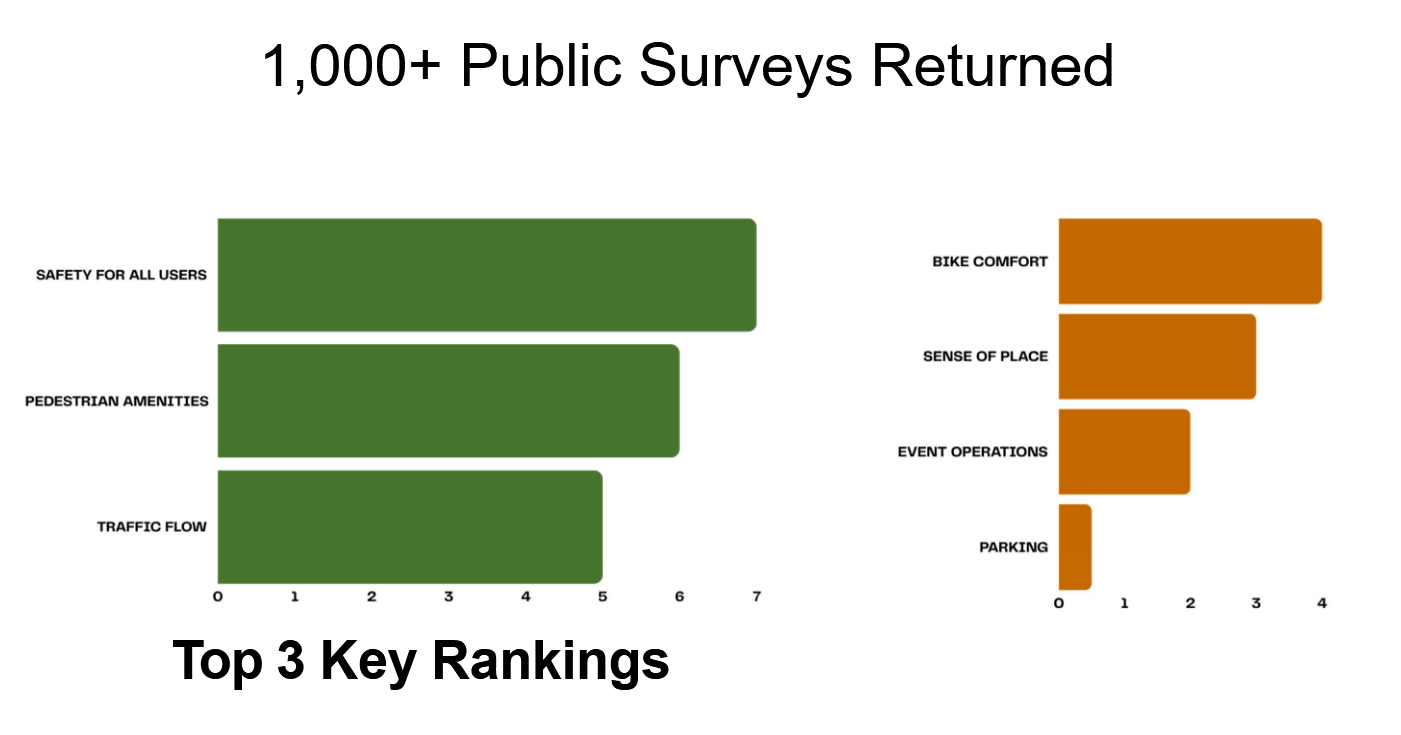
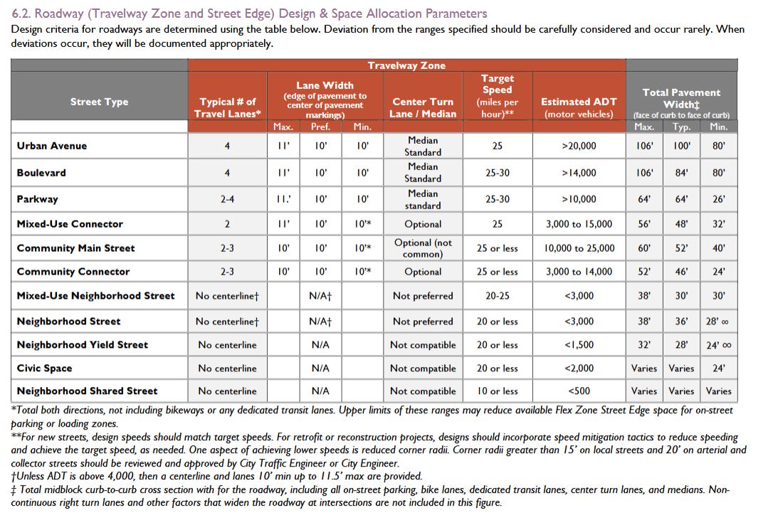
Johns Hopkins Bloomberg School of Public Health studied lane widths across seven cities in several states. They found that narrow lanes save lives. Crash reductions are significant when reducing streets from 12 foot lane widths to 9 feet. The conventional wisdom of “larger lanes are safer” is wrong. The goal that cities and states should aim for, especially in urban contexts, is to narrow lanes as much as possible (10 feet). When engineers want to go wider, they need to justify that decision. NACTO, the National Association of City Transportation Officials, also agrees with this guidance. Notably, the City of Madison agrees with it too! The Complete Green Streets guidance calls for 10 foot lanes on “Community Main Streets”:
Elected officials were voted in because they prefer safety over convenience. They want to reduce deaths to zero. They are interested in making dynamic places where people want to be rather than subsidizing parking lots.
Staff have shown a desire to ease vehicle access. They can tell you how long cars will have to wait at an intersection, but not how long people will need to wait to get a safe crossing. They claim lanes need to be wide for five ambulance trips a day, but not narrow to reduce the 22 injuries that have occurred to pedestrians and bikers since 2017 for the vast majority of the remaining time (more than 99%).
There’s a miscommunication here. In the words of Chuck Marohn:
It is now Madison Common Council’s time to ask staff to help them understand the Regent Street redesign.
- Is this design truly prioritizing safety like Complete Green Streets and Vision Zero would have us do?
- What would a “safety first” redesign look like? What amenities could we add to Regent with the extra space?
- Why are 14-foot lanes required for a Community Main Street? When designing with 14-foot lanes, are we designing for the majority of uses, or for small, niche uses?
- Streets are a liability, the people and places around them are the assets and investments we want to promote. Have we conducted a financial analysis on the return on investment needed for a road that prioritizes vehicle passage (property damage, reduced business, less housing) compared to a street that prioritizes safety and people (improved property values, better community spaces, more business opportunity)?
I hope alders will prioritize safety over vehicle convenience. I hope they can see that wide lanes will cause more damage. Approving the design as is would be admitting to not prioritizing safety, which for some would break promises made during campaigns.
There is no excuse this time. Regent Street is not under state jurisdiction. Common Council is in control of what this design looks like and every guide and handbook is telling them they can make it safe.
Two lanes. 10 feet each. That is all Regent Street needs to be a successful street in Madison.
[[divider]]
This article was originally published, in slightly different form, on Local Conversation leader and Strong Towns member Josh Olson's Substack, Counting Cranes. It is shared here with permission.
.avif)
When most people hear about a traffic crash, they immediately look for a cause: a distracted driver, a pedestrian who wasn't paying attention, or someone who made a mistake.
But for Malisa McCreedy, Transportation Manager for the City of Ann Arbor, Michigan, the most important question is often much bigger than that.
As Ann Arbor implemented the goals of its Moving Together Toward Vision Zero Comprehensive Transportation Plan, city leaders recognized that crashes are rarely isolated events. Crashes are the product of a system: street design, speed, visibility, land use, lighting, enforcement, expectations, and countless other factors that shape how people move through a place every day.
That realization led the city to create a multidisciplinary Crash Response team that meets monthly to review serious crashes that occur in the city. Representatives from the police department sit alongside city staff responsible for every aspect of the public right-of-way, from day-to-day operations to long-range planning. This team examines what happened, but more importantly, they ask why the system produced that outcome.
The Work Wasn't Always Easy
As the Crash Response team dug deeper into crash analysis, they discovered that understanding the crash and explaining the contributing factors were often two different challenges. Ann Arbor Staff could identify multiple contributing factors, but communicating those findings to the public proved difficult. Community advocates wanted answers. Residents wanted accountability. Yet reducing a crash to a single cause often obscured what the city was learning.
Malisa in her role as Transportation Manager introduced the Strong Towns' Crash Analysis Studio to her team to tackle this struggle. The Crash Response Team strengthened both their review process and their ability to communicate what they were finding. The Studio helped shift conversations away from blame and towards understanding. Instead of asking who was at fault, the Crash Response Team became better equipped to ask what conditions contributed to the crash and what changes could make future crashes less likely.
Just as importantly, Malisa discovered that Ann Arbor was not alone in this work. Through Strong Towns, city staff were connected to a broader community of practitioners, local leaders, and transportation professionals grappling with many of the same questions. How do you talk about crashes without reducing them to a single cause? How do you help residents understand the role that street design plays in safety outcomes? How do you create space for learning while still responding to community concerns? The value wasn't simply a new process. It was the confidence that comes from learning alongside others who are committed to making their communities safer.
That shift has had real results. Ann Arbor has seen a reduction in overall crashes and is now able to focus more attention on the most serious crashes as it continues pursuing its Vision Zero Comprehensive Transportation Plan objectives.
What makes this story compelling is not that Ann Arbor found a simple answer. It's that city staff embraced the complexity of the challenge.
Strong Towns often talks about the danger of false confidence. Cities are complex systems, and meaningful change rarely comes from a single solution. It comes from observation, learning, collaboration, and the willingness to ask better questions.
Malisa's work demonstrates what that looks like in practice.
As a Strong Towns member, Malisa is helping bring these ideas into the daily work of local government. She is showing that safer streets are built not through certainty, but through curiosity, humility, and a commitment to learning from every experience.
Strong Towns members make this work possible. Their support helps communities access programs like Crash Analysis Studio, connect with peers facing similar challenges, and build the capacity to learn from experience. Members are not simply supporting an organization. They are helping create a movement where local leaders can find the tools, encouragement, and relationships needed to take the next prudent step toward safer and stronger places.
That work doesn't happen all at once. It happens one conversation, one crash review, and one lesson at a time.
.avif)
When people talk about traffic safety after a serious crash, the conversation often begins with a simple question: Who was at fault?
It's an understandable question. It is also often the wrong place to start.
That realization shaped the work of Michelle Melin-Rogvin, a Village Commissioner in Forest Park, Illinois, and a Strong Towns member participating in the 2025–2026 Strong Towns Cohort.
Forest Park is a small community with relatively few roadway fatalities. Yet village leaders have seen a troubling number of serious crashes and near misses. Like many communities, Forest Park already had a Traffic Safety Commission dedicated to addressing these concerns. The challenge was not a lack of commitment towards safer streets. It was a lack of structure to take action.
When crash reports came before the Commission, the contributing factors were often unclear. Discussions quickly became unfocused, and meetings frequently ended without a clear path forward. The Commission had people who cared deeply about safety, but it lacked a framework for understanding what a crash might reveal about the broader transportation system.
As part of her Cohort project, Michelle explored a question many local leaders face: How do you shift the conversation?
Through Strong Towns, she was introduced to the Crash Analysis Studio. Rather than focusing on a single person to blame, the Crash Analysis Studio encourages communities to look at the many factors that contribute to a crash: street design, visibility, speed, land use, traffic patterns, and more.
Michelle began applying that mindset in Forest Park. She started by asking village staff to collect information beyond the initial police report after serious crashes. She encouraged staff to meet internally to identify contributing factors and then bring those findings to the Traffic Safety Commission for discussion. Instead of debating fault, The Traffic Safety Commissioners could begin exploring the next small steps that might reduce risk in the future.
The response has been encouraging. Village staff, fellow commissioners, and the mayor have all responded positively to a process that creates space for learning rather than blame.
What makes this story compelling is that Michelle did not arrive with a grand solution. She did not claim to have all the answers. Instead, she found a better way to ask questions.
That reflects one of the most important lessons of Strong Towns: our communities are complex, and meaningful change often begins with humility, curiosity, and a willingness to learn.
Strong Towns members make this work possible. Through programs like the Cohort, local leaders like Michelle gain access to ideas, tools, and peers who help them navigate difficult challenges in their own communities. The result is not a one-size-fits-all answer. It is a growing network of people learning how to make their places stronger, one prudent step at a time.
Michelle's work in Forest Park is a reminder that better conversations can lead to better outcomes. And sometimes, changing a place begins by changing the questions we ask.
.avif)
When Bill Price joined Strong Towns as a member and later participated in the Strong Towns Accelerator Program, he wasn’t looking for a silver bullet.
Like many local leaders, he already understood the challenges facing his community. As Board President of the Community Design Center Rochester, he spent his time thinking about the future of Rochester, New York, and the difficult questions surrounding transportation, housing, and neighborhood development.
The problem wasn’t a lack of ideas. The problem was figuring out what to do next.
Bill and Community Design Center Rochester Executive Director Dawn Noto entered the Strong Towns Accelerator through the Confessions of a Recovering Engineer course. The program focused on transportation, an issue that resonated in Rochester. The city had already removed a downtown freeway and reconnected neighborhoods that had been divided for generations. Yet that success revealed a new challenge: once a major victory is achieved, where do you go from there?
Through the Accelerator, Bill and Dawn encountered a different way of approaching local problems. Rather than searching for a comprehensive solution, they learned to start with a clearly defined struggle, bring together the people closest to it, and identify the next smallest step.
A year later, they applied those lessons to a different challenge: housing.
Like many communities, Rochester faces a shortage of homes. But Bill and Dawn recognized that the city wasn’t lacking organizations, advocates, developers, or neighborhood leaders willing to help. What it lacked was a shared framework for moving forward together.
Drawing on ideas from the Accelerator and the Housing-Ready approach, they convened dozens of organizations working on housing issues across Rochester. Instead of debating competing solutions, participants focused on identifying the obstacles they were encountering and the struggles they were hearing throughout the community.
The result wasn’t a master plan that would sit on a shelf. It was something more practical that could result in action.
Together, the group identified four areas where coordinated action could make a meaningful difference: creating pattern books and pre-approved building plans, developing a stronger economic narrative for housing, expanding opportunities for incremental development, and streamlining permitting through a faster approval process.
Those conversations eventually led to a community housing lecture series hosted by the Community Design Center Rochester. Strong Towns participated as a keynote speaker, but the most important work happened afterward. Local leaders stayed for a four-hour workshop focused on identifying concrete next steps within each of the four focus areas.
The conversation shifted from discussing the housing crisis to determining what each group could do next.
That shift captures something important about how Strong Towns works.
Many communities do not suffer from a lack of caring people. They suffer from a lack of connection, coordination, and confidence about where to begin. Programs like the Strong Towns Accelerator exist to help local leaders navigate that complexity, connect with peers, and discover practical next steps that build momentum over time.
As a Strong Towns member, Bill helped bring those lessons home to Rochester.
The goal was never to solve housing issues overnight. The goal was to help his community take the next prudent step.
And then the next one after that, and the next one after that.
That’s how strong towns are built.
.avif)
.avif)
In 1908, regular recipients of the Sears, Roebuck & Co. Catalogue were offered another publication in the mail: the Book of Modern Homes and Building Plans. Within its pages were 44 home design and construction kits that customers could purchase for as little as $360 — roughly $15,000 today when adjusted for inflation. The homes were shipped by railroad boxcar almost anywhere in the United States or Canada in crates containing nearly everything needed for building, from the lumber and nails to the wallpaper and fixtures.
By 1916, innovations such as pre-cut lumber and an early form of drywall further reduced both costs and construction time. These changes also made it possible to build homes without relying on master carpenters or tradesmen. Construction often became a family and community effort, with even people possessing only basic building knowledge able to contribute. Competitors soon followed Sears into the market, and by the end of the Second World War more than 100,000 catalog or "kit" homes had been built across North America.
Sears Homes helped bring the dream of homeownership within reach for middle- and working-class Americans. Additionally, for many Black Americans it became a way to achieve said goal without the fear of being turned away at the local hardware store, or being charged more money for the same tools and materials simply because of the color of their skin. More than a century later, amid rising housing costs and an affordability crisis, Detroit is revisiting this antique, yet salient, idea.
Earlier this month, the City of Detroit put out an RFP (request for proposals) for a series of pre-approved housing plans that will cut through the red tape of permitting delays, restrictively zoned neighborhoods, and the comparatively small residential lot sizes of the city. The goal is twofold: lower development barriers, and ensure that new housing fits the character of existing neighborhoods.
While the program is not a panacea for the broader housing affordability crisis (rising labor and material expenses will remain major challenges) a library of pre-approved designs could significantly reduce bureaucratic delays and administrative overhead for developers both large and small. The RFP document itself lays out the City’s thinking; “Once designed, the building plans are available for public use and have a pre-approval status such that complete applications could be approved to build in a matter of days.”
Initially, the program will focus on single-family detached homes as part of Mayor Mary Sheffield’s goal of adding 1,000 such structures to the city during her first term. Although this effort’s focus is currently limited to that type of housing based on the Mayor’s campaign promise, there is no reason that the concept could not eventually expand to include duplexes, fourplexes, and small apartment buildings.
Many of Detroit’s pre-World War II neighborhoods already contain these types of housing stock and other cities — including Michigan’s own Kalamazoo — have incorporated them into similar pre-approved design libraries. With the RFP specifying that the designs must take into account the existing character of these neighborhoods this may well put at ease critics who worry that contemporary architectural designs do not mesh well with the historic homes of older neighborhoods.
The hope is that the new builds will fit seamlessly in among existing homes and structures that are often approaching their 100th birthdays: many of them being the very Sears Homes that form the kernel of this idea in the first place. Homes built over a century apart, but linked through time by now over a century of an excellent idea.
[[divider]]
This article was originally published, in slightly different form, by the Local Conversation group Strong Towns Detroit. It is shared here with permission.
%20(1).avif)
Transportation in Duluth, Minnesota, had a pivotal year in 2025. The resurfacing of Sixth Avenue East in the Hillside neighborhood made a previously unapproachable corridor more pedestrian-friendly. Duluth also welcomed a new BikeMN chapter, Vibrant Streets Duluth, and city councilors voted unanimously to establish the city’s first transportation commission.
In early December, members of Vibrant Streets Duluth, supported by Councilors Azrin Awal, Deborah DeLuca and Roz Randorf, introduced a motion to explore redesigning First Street downtown as a “Flow Street.” The proposal asks the new transportation commission to study the concept and return with recommendations within nine months of its first meeting.
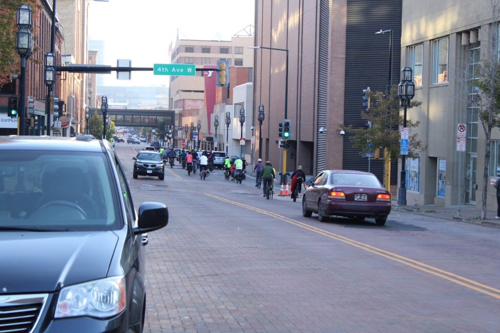
What is a Flow Street?
Flow Streets build on the Slow Streets movement, which began in Europe and Canada and expanded across the United States during the COVID-19 pandemic. Cities sought safer ways for people to move and exercise while maintaining distance. Since 2020, versions of Slow Streets have appeared in cities such as San Francisco, Portland and Seattle.
Slow Streets typically include speed limits under 20 mph, signage discouraging cut-through traffic and protective elements such as bollards near crosswalks, sidewalks or bike lanes.
Flow Streets expand on that approach. Vibrant Streets Duluth describes them as “safe, comfortable, low-vehicle-traffic routes that prioritize community-building through active transportation.” Rather than eliminating cars, the concept aims to rebalance spaces with slow speeds so walking, rolling, biking and driving can coexist more safely and comfortably, all while allowing for cars and delivery vehicles to maintain access to properties and parking.
Why First Street?
Just one block uphill from Duluth’s main downtown corridor, First Street was recently converted to two-way traffic. About 25 blocks — from Sixth Avenue West to 21st Avenue East — are being considered for the Flow Street concept.
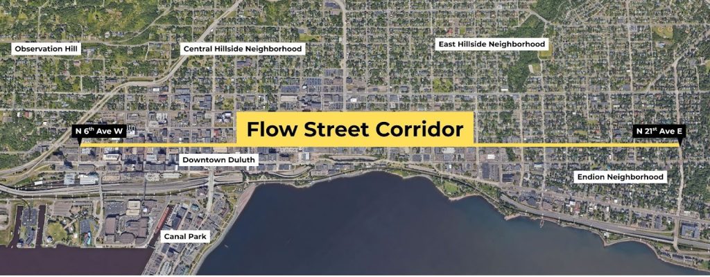
This stretch runs past multiple downtown destinations, including municipal buildings like City Hall and the Chamber of Commerce, a string of people serving non-profits including Safe Haven, PAVSA, the YMCA, and United Way, and accesses many of Duluth’s healthcare buildings like WE Health, Essentia Health, and Aspirus. First Street is also home to several long-standing historical buildings and spaces, such as the Building for Women and the Clayton Jackson McGhie Memorial.
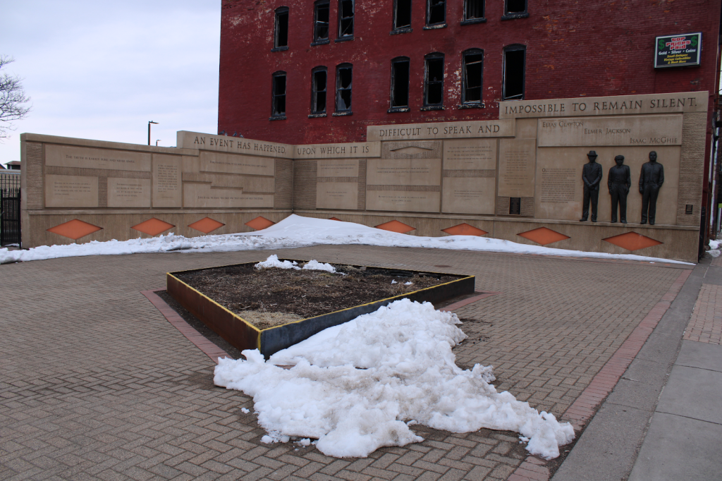
Libby Bent, a founding member of Vibrant Streets Duluth and longtime bike commuter, says First Street has long served as a practical route through downtown because of its relatively low traffic volumes, flat terrain and proximity to amenities. As Duluth works to revitalize downtown, Bent says a calmer, multimodal street could help people more easily connect with local businesses and organizations — interactions often missed when traveling by car.
At the same time, parts of the corridor show visible disinvestment, including fire-damaged buildings, vacant lots and underused properties. Mary Faulkner, Executive Director at the Program for Aid to Victims of Sexual Assault (PAVSA), located in the Building for Women on First Street notes; “The proposed changes would increase the accessibility and safety of our neighborhood and create a more conducive environment for seeking healing and wellness. Our First Street neighborhood has so much potential and is ready for revitalization efforts that have been so successful across Duluth.
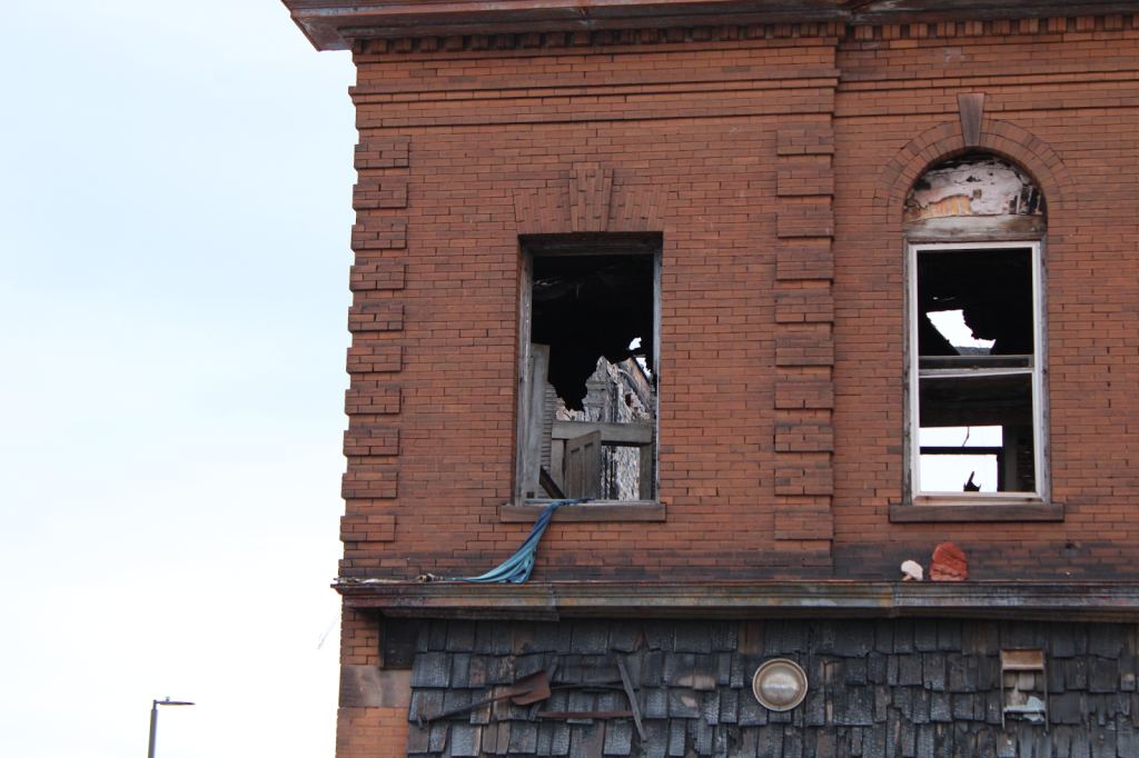
A Flow Street could help reshape not only the physical environment but also the daily experience of the area by encouraging steady, human-scale activity. Other advantages, cited on the Vibrant Streets Duluth website, include a pedestrian alternative to the popular Lakewalk and a connection between downtown and Lincoln Park.
Behind the Scenes: Urban Excellence Institute
Formal study of the Flow Street concept won’t begin until city staff and City Councilors appoint members of the new transportation commission, expected to happen yet this spring. But work continues through the newly formed Urban Excellence Institute. That initiative connects stakeholders, including staff from the City of Duluth, the University of Minnesota Duluth, business owners, community non-profits and community residents, to advance projects aligned with Duluth’s Imagine Downtown Work Plan. Goals include improving safety, growing local businesses and promoting the interconnectedness of neighborhoods.
Jennifer Webb, an associate professor of art history at the University of Minnesota-Duluth, and Duluth City Planner James Gittemeier, who teaches an “Introduction to Urban Planning” course at UMD, are incorporating the Flow Street concept into their courses, engaging students in the Flow Street project and other downtown initiatives.
“We want to find ways to build capacity and include student engagement,” says Webb, adding that the university is well positioned to work with Duluth and Superior, Wisconsin — commonly known as the Twin Ports — to be collaborating. Their classes will merge efforts on a demonstration project ideas over the next few months, implemented along First Street in summer 2026.
When a Duluth Flow Street becomes reality will hinge on the city’s new transportation commission.
[[divider]]
This article was originally published, in slightly different form, on streets.mn. It is shared here with permission.
.avif)
.avif)
A hundred years ago, the American dream was the want to be a small business owner. People flocked to America in droves from around the world in search of a better life — bringing their cultural influences with them. They opened bakeries. Corner stores. Taverns. Breweries. Ice cream shops. Grocery stores. Newspaper shops. In a suburban building surrounded by parking? Absolutely not — neither cars nor zoning existed back then. These were simple two- and three-story, mixed-use, commercial buildings that were sprinkled within dense residential neighborhoods, with storefronts on the first floor and apartments above. They were built intentionally and incrementally over time with the goal to last generations.
The exterior of these legacy shops were lovely, but what went on inside was magical. These mixed-use buildings served their owners twofold: allowing for their business to thrive and providing a safe place for their family to grow. For decades, these legacy neighborhood shops within residential neighborhoods played an essential part of our society, providing jobs, food, necessities, products, and often, a third place away from home and work where people could dance, drink, learn, and socialize.
Sadly, with the rise of the automobile and nearly every city in America adopting suburban-style zoning codes in the 1950s and 60s, these neighborhood shops became illegal. We know the arguments people had…and still have today. As a zoning board official, I can hear them now: No parking? No front yard?! A commercial space in a residential neighborhood?! No way!
So what happened? Why are so many of these mixed-use buildings often vacant today? Unloved? Non-financeable? Sadly, the adoption of suburban-style zoning codes made them illegal and that, combined with increasing car dependency and our shift to corporate big-box stores, led to the ultimate demise of many of these neighborhood shops. One by one, they closed. And with each closure, the properties declined in value and neighborhoods often lost their “glue,” causing more and more people to drive to big box stores on the outskirts of town to get the needs that were once met within walking distance. If the building doesn’t have value, the banks won’t lend for repairs. Disinvestment consumes the buildings. Neighborhoods that once contributed greatly to the tax base lose property value, which means they lose taxable income for needed services. The cycle is vicious.
Today, many Americans live in legacy cities with those old legacy neighborhood shopfronts still tucked inside residential districts. Some are vacant. Others converted to residential apartments. If you’re super lucky, maybe you have an existing legacy business from yesteryear that is still in operation.
So, what can we do to bring these spaces back to life? How do we reverse this cycle? Let’s look to Buffalo, New York, as an example.
Buffalo, like many legacy cities, has a ridiculous amount of these legacy shops in residential areas (not necessarily on a main street or commercial artery), just sitting there waiting for love. A hundred years ago, it was the Italians who came to my neighborhood and built these buildings. I counted 35 of them in my neighborhood on a bike ride once. Thirty-five! Imagine 35 small businesses contributing to the local economy. If each business had two or three employees, that would be 100 jobs in the neighborhood. That's 100 people renting apartments or buying houses, shopping locally, going out to dinner, paying taxes, etc. The small spaces are humble, allowing for them to remain affordable throughout time. Their presence adds to the walkability of the neighborhood, which increases property values, and each little shop increases the strength and resilience of the local economy. This, in my humble opinion, is where we should focus economic development dollars in our neighborhoods—though sadly, it is often ignored.
Buffalo took a bold leap when we passed the Buffalo Green Code in 2017. Most of the Strong Towns folks know us for being the first major U.S. city to get rid of minimum parking requirements citywide. But we took many other bold actions in the code, one of which being Section 6.1.1.F, the neighborhood shops provision. With one paragraph (and some nuanced details), we legalized these commercial buildings sitting inside residential neighborhoods—allowed with a special use permit! You can read the code and the specific provision details here.
Neighborhood Shops. An applicant is eligible to apply for a special use permit to establish or expand a commercial use in the N-2R or N-3R zone where the below criteria are met, irrespective of the limitations of Table 6A: These criteria are intended to allow existing commercial buildings in residential zones to be utilized to incubate small businesses and artisans in order to serve as catalysts for neighborhood revitalization, as a tool for economic development, and as an important component of the walkability of a neighborhood.
The change in the code has, without question, led to dozens of projects throughout the city. The reopening of these legacy spaces for barber shops, bodegas, halal markets, restaurants…just one small paragraph in the code has opened the door for the American dream to be fulfilled yet again.
Here are a few examples of lessons learned from Buffalo!

Tipico — Now Khari’s Cafe
Prior to the Green Code passing, we needed to build consensus around the idea of allowing these legacy neighborhood shops to be legal again. It was the Tipico Coffee project (now Khari’s Cafe) that helped the community understand that these legacy shops could be something magical. This less than 1,000-square-foot shop rounds out a corner in a historic residential neighborhood. It doesn’t have parking. Once renovated, it won several design awards and was even featured in Dwell Magazine.
A few neighbors opposed the project due to a lack of parking but quickly found out that the business was an asset. The coffee, food, and beautiful space to hold meetings worked well for the neighbors and students who attended the college down the street. And the parking problems? Believe it or not, when you have people coming and going every 15 minutes for their coffee, the parking tends to actually turn over quickly. Today it is a gem in the middle of a residential neighborhood.
Lesson for the community change makers out there: If you’re thinking about doing this kind of provision in your code, look to already existing ones in your community that people love.


Foibles Coffee & Pie
Full disclosure, I am an incremental developer in Buffalo, so this is a personal example.
Flashback to 2018. The Green Code had just passed. I got a text asking if I wanted to buy a little mixed-use building in my neighborhood. It had a boarded-up storefront (untouched since 1960) and two apartments—a perfect little project! I said, “heck yes,” because I knew about the neighborhood shops provision in the Buffalo Green Code that would allow that shopfront to be open again. Sadie Mathers, now the owner of Foibles Coffee & Pie, came by my office to pay her rent (she was an existing residential tenant) and told me about her dream to open a pie shop. We zoomed over to the vacant storefront space and in seconds, she was in love with all 550 square feet of it.
It wasn’t easy — it took several banks, construction folks, permits, and weekend painting with the family to cut costs and keep the rent affordable. It all came together in March 2020 with approval of the special use permit and nearly 20 letters of support from the community. Today, Foibles Pies is a little dream come true, contributing to the walkability and economic resilience of the neighborhood.
Lesson for the building hackers out there: Can you bake pies with electric ovens and avoid building code hurdles? Answer: Yes, you can. We purposely avoided gas in this project. Electric mini split, electric hot water tanks, electric ovens. Because of this decision, we didn’t have to install a sprinkler system, saving tens of thousands of dollars, which helped to keep Foibles’ rent affordable.
Lesson for anyone trying to get money to do their project: If your business is food, don’t be afraid to bring food samples to your bank loan committee meetings, community engagement meetings, and, ya know, everywhere you can to lift spirits and gain support.

Eugene V. Debs Hall : A Labor History Social Club
On a very cold day in January, Chris Hawley and I walked through an old tavern in a residential neighborhood on the East Side of Buffalo. Vacant lots and an abandoned art deco train station surround the tavern — a result of using urban renewal monies over the last decade to demolish abandoned homes. This once was the heart of old Polonia but since 1950, about 85% of the population left.
Chris had a dream to open a social hall dedicated to labor union history and organizing. Vacant since 1991, the historic bar from 1914 sat cold…but completely intact. The historic tavern, two apartments upstairs, a Model T garage, and a separate house — the whole package was available for $40,000. Thanks to the efforts of a neighbor who bought it for $1 to protect it, it remained in stable condition, which allowed this project to be possible.
I looked at Chris and said, “If you don’t buy this, I will.” The numbers worked. The building was in great shape. The removal of the minimum parking requirements, combined with the neighborhood shops provision in the Green Code, allowed this old, dusty tavern to easily open again — with an easy special use permit. No variances.
We got to work! Chris took an Incremental Development training course, and the renovation financing came through. We created a board for the non-profit hall. Restored the tavern. Renovated the apartments. A year and a half later, Eugene V. Debs social hall opened with over 200 founding members and a fully leased building.
“This project allowed me to do what I wanted to see happen as a city planner,” says Chris. “We used the Green Code as God intended: to reactivate an unsung space in a venerable old neighborhood that planners in the urban renewal and interstate era believed should not exist. A walkable vision for the East Side is viable again because the zoning regulations changed.”
Lesson learned: Incremental steps in a place that is struggling is often the only way to make financial sense of the renovation.
To be clear: These are all commercial uses in residential zoning districts, and they’re now legal.
The moral of the story is simple: these legacy neighborhood shops matter. They deserve to be loved because they give back to the community more than they take. As we look to the future and the many potential problems we will face if we allow our current development pattern to continue unchecked, we need to ask ourselves: What does America deserve to look like? I can’t say that an affordable, 550-square-foot storefront will save the world, but I can say that the provision to allow such spaces in our neighborhoods, if adopted in cities and towns across the country, could absolutely be a part of the solution.
[[divider]]
This article was originally published in May 2022. You can hear more from Bernice Radle this month at the Strong Towns National Gathering!
