
Strength Test #1: How's your Main Street doing?
This article is the first in a series on the Strong Towns Strength Test, a simple method to help determine your town's strength and resilience. This series offers step-by-step guides for giving your town the test along with ideas for actions you can take to help your town grow stronger. We'll publish one article in this series every week.
The question we're exploring today is:
“Take a photo of your main street at midday. Does the picture show more people than cars?”

This is the first item on the Strength Test for a reason. It helps us understand on a very basic level whether your town is filled with cars passing through, or people enjoying your city center as a destination. At Strong Towns, we call humans the “indicator species of economic health.” If you’ve got a lot of them walking around, visiting your town’s businesses, enjoying your town's amenities and living in your town’s homes, you’re well on your way to being a strong town. That means you have an economic base to support your community and people who genuinely want to live in your place and contribute to it.
On the other hand, if your main street is devoid of people and merely a thoroughfare for cars, that tells us about your town’s auto-dependence (which makes infrastructure costs expensive) and it tells us about the tax base of your community. In our analyses of tax value per acre in city after city, we find that downtown cores and main streets are the most economically productive places. If yours is vacant, that means your city is missing out on this productivity. Roads and intersections don’t offer tax base. Auto-oriented developments like big box stores and fast food restaurants contribute little tax base. Instead, it’s the fine-grained, mixed-use downtown buildings that typically provide the most long-lasting wealth for a community. Here are some more examples of that.
By beginning the Strength Test with this question, we are asking whether your town—specifically, the center of your town, the place where the action is most likely to happen—is a place that people go to or go through. If you take the test and find that your answer to the question Does the picture show more people than cars? is “No,” you’ll have an immediate idea of where you can get started on working to make your town stronger. As with any organism, when the heart is not healthy, the rest of the body cannot truly thrive. Determining how many people vs. cars frequent your downtown gives you a clear idea of how healthy the heart of your city is.
How to Take the Test
This is one of the simplest items on the Strong Towns Strength Test. The only things you'll need to complete this task are a camera (or phone with a camera) and a few minutes of time on your main street. Let's get started.
1. Figure out where you main street is. The first part of the test requires that you figure out where your main street is. If you live in a small town, you probably have a pretty distinct main thoroughfare that is the heart of your core downtown. Maybe it’s even called “Main Street.” It might look something like this:
Main Street, Newark, DE (Image from Wikimedia)
But if you live in a suburb, you may not have such an obvious central commercial street. Your main street might be a stroad full of strip malls, either because your historic downtown has been demolished or because your suburb never had one to begin with. And if you live in a big city, you might have several streets that feel like “main street” to you.
For the purposes of this exercise, pick one: Choose the busiest street with the most businesses—the one you’d expect to be full of people heading to lunch on a weekday at noon. (Here’s another trick I like to use to help determine where a downtown or main street is: Search for your town on Google Maps and zoom out to see where the name of your town is placed on the map. That’s typically the downtown.)
2. Take your picture. Your next task is simple: Find a time to visit this street during the week at midday. Bring a phone or camera. Position yourself near the midpoint of your main street, or the busiest part of it. Now take your photo. It’s best if you can take it from the middle of the street. This will require crossing carefully or at a green light obviously. Take a few pictures to make sure you get a good one. Take the widest shots possible.
3. Review the results. Time to assess. Examine your photos and count the cars and people. When that’s finished, consider the results. Did you see five cars and one person? Ten cars and twenty people? If your ratio is more than 1:1, you’ve got a problem. And if you saw neither cars nor people, that’s a big red flag too.
Next Steps
If you took this test and found that your main street was more of a thoroughfare for cars than a destination for humans, there are some steps you can take to help change that:

Main Street, Dallas, TX. Cars: 4. People: 1. (Image from Wikimedia)
1. Share your results. First, share your results with friends, neighbors and local leaders. Publish the photo(s) on social media with the hashtag #StrengthTest. Or take it further and share it on a local blog or in a local paper. It might seem funny to show your neighbors a photo of a street they’ve probably seen hundreds of times, but it’s amazing how little we pay attention when we’re walking or driving. When you show people that picture and ask them, How many people do you see? and What’s wrong with this picture? you’ve begun a conversation.
Want to make an even bigger impact? Use the internet or a local historical society to find a photo of that same main street 70-100 years ago, if your town existed back then. I bet that photo has far more people in it than your current photo. This sends a clear message too.
2. Try a longer analysis. Not convinced by this quick analysis? Try a longer process where you visit your main street between 12pm and 1pm with a friend. Decide which of you will count cars and which of you will count people. Keep a tally going throughout the hour (make sure not to double-count people who enter and then exit a store, and not to double-count parked cars). Compare the results after the hour is up.
3. Ask why. One of the most important next steps is to ask yourself (and your friends, neighbors, etc.) why there aren’t more people. Is it because the sidewalks are unpleasant or unsafe? Is it because there aren’t many businesses on this street, or because the businesses present aren’t popular? Maybe there are a few businesses but they’re separated by parking lots and vacant storefronts, making this downtown an unappealing place to be. Are there few people here because your main street isn’t connected with other parts of town or because few people live or work around here (and thus don’t really have a reason to be here)? Are people not coming here because the fast food restaurants on the edge of town draw more customers than the local restaurants downtown?

Find more strategies to slow cars and create a pedestrian-friendly environment here.
Considering the Why will help you decide what to work on. There are likely multiple reasons why your main street is not thriving. Begin by focusing on one, gathering together neighbors (or joining an existing neighborhood group) and strategizing ways to make a change.
For example, if you main street is empty because most of the buildings are vacant, consider a pop-up storefront initiative where local businesses that don’t have premises can temporarily use empty storefronts for a reduced price (or even free). Here's an example of a successful pop-up storefront initiative in the town of Viroqua, WI.
If your main street is empty because it’s not a pleasant place to walk, put in cheap chairs or benches, consider decreasing the width of the street so that cars drive slower, patch holes in the sidewalk, put up planters or trees… The Tactical Urbanism Guide has plenty of ideas to get you started.
4. Bonus: Do a value per acre analysis of your main street. If you'd like to make the case for a better main street in hard numbers, consider doing a value per acre analysis of your main street, comparing it with another street on the edge of town. Here's a video that shows you how.
Towns that Get Main Street right
We'll conclude with some inspirational examples of towns that answer a resounding "Yes" to the question, Does the picture show more people than cars? The photo below was taken by Strong Towns contributor and founding member Andrew Price in his hometown of Adelaide, Australia. This is Hindley Street:

I count 22 people and 6 vehicles (and 1 bike!). Why is that? The people are heading towards the many restaurants and businesses that line the street. Some of the people in the photo look like they're out for a jog as well. Many look fairly casually dressed but some seem to be on their way to or from an office job as well. Overall, it seems like a pleasant and safe street with plenty of businesses attracting people to it. These are some of the reasons it's busy.
And why are there so few vehicles on Hindley Street? First, it looks like parking is somewhat limited on the street. Second, and more importantly, this street is quite narrow. It's clear that the purpose of the street is to be a place for thriving businesses and people walking to them—not for cars to move quickly through. If that were the case, the street would be much wider with more lanes—and it would be a far less desirable place for pedestrians.
Let's take a look at another street.

This photo (also by Andrew Price) features a pedestrian main street in Boston, MA. We don't have to count them to know that there are hundreds of people and zero cars. Not only is this street full of residences, productive businesses (no empty storefronts here) and people visiting them, it's also much cheaper to maintain than an auto-oriented street. The wear and tear created by humans walking on the street is far less than the wear and tear created by cars and trucks on a street. Additionally, the width of the street is much narrower than it would be if it was built for cars, which means a lower cost as well. The narrow streets also mean that we can fit more businesses within this neighborhood because less of the land is taken up by asphalt and intersections.
While this street is housing modern-day businesses, it's clear from the design and cobblestones that it was built long before our modern zoning and street design policies. Figuring out how to build a street like this in your community would be a challenge. That's something we'll address in a future Strength Test article (see item #3).
Now that you've got the information on how to conduct this test, we want to hear how it goes. Let us know in the comments, by sharing your photos on social media with the hashtag #StrengthTest, or by emailing us.
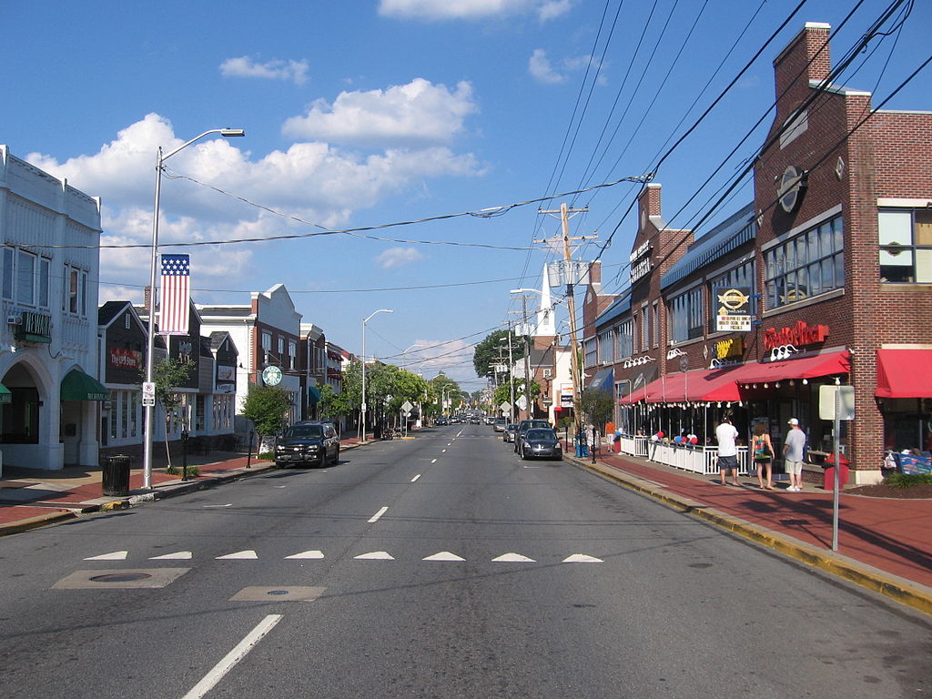
(Top photo of East Main Street in Lancaster, OH. Photo by Tim Kiser)
Rachel Quednau serves as Program Director at Strong Towns. Trained in dialogue facilitation and mediation, she is devoted to building understanding across lines of difference. Previously, Rachel worked for several organizations fighting to end homelessness and promote safe, affordable housing at the federal and local levels. Rachel also served as Content Manager for Strong Towns from 2015-2018. A native Minnesotan and honorary Wisconsinite, Rachel received a Masters in Religion, Ethics, and Politics from Harvard Divinity School and a Certificate in Conflict Transformation from the Boston Theological Interreligious Consortium, both in 2020. She currently lives in Milwaukee, Wisconsin, with her husband and young son. One of her favorite ways to get to know a new city is by going for a walk in it.