A Town Well Planned: Street Design
This article is part of a series in which Strong Towns member and contributor Alexander Dukes proposes a design concept for redeveloping a neighborhood in his college town of Auburn, AL. We hope it serves as valuable inspiration when thinking about design options for your own neighborhood.
Read previous articles in this series:
Click to view larger
The first article in my “A Town Well Planned” series proposed a three-part regulatory system for managing the design of urban environments. The series refers to this system as the “Civic Development System,” or “CDS” for short. The three pillars of this regulatory system are: (1) The Master Street Plan, (2) Basic Land Use Zoning Plans, and (3) Form Plans.
My most recent article described how The City of Auburn, Alabama could use a Master Street Plan to design the subdivision of the Auburn Mall site. (You may want to read that article first if you haven’t to gain some context about the mall site, Auburn’s geography, and design work done so far.) The mall site was subdivided by using a common set of parcel types that are small, slim, and evenly divisible by one another. Within these parcels, city “blocks” were constructed.
So far, the Master Street Plan for the Auburn Mall site (see the image on the right) only displays blocks and the parcels those blocks consist of. The negative spaces between blocks are the rights of way where streets and alleys will be placed.
Today we're going to discuss how a Master Street Plan can be used to design streets that fill the right of way between blocks of parcels. These streets will serve the residences, shops, offices, and manufacturers that will eventually exist within the former mall site. Because the parcels were designed to be evenly divisible, their rights of way are roughly separable into a three basic widths. These widths will serve as the basis for our street designs, which (like the parcels) will be limited to a three types that can be used throughout the design.
Note that it is important to differentiate this article’s street design portion of the Master Street Plan from the previous article’s subdivision/parcel design portion. In a city, a Master Street Plan essentially serves two purposes: The first purpose is to define how developers can subdivide municipal lands (as described in the previous article). The second purpose is to define how the city’s rights of way will serve the developers’ subdivisions. This article defines how we are going to serve the mall site subdivision with streets. Put simply, the subdivision/parcel design portion of a Master Street Plan regulates the physical arrangement and legal division of private space, while the street design portion regulates the city’s design of public space.
Within the mall site’s subdivision design, there are essentially three basic right of way widths: wide, standard, and narrow. The widest right of way widths are within the center of the site to function as “boulevards.” These boulevards will facilitate a communal forum and encourage the patronization of shops that are likely to grow up around the park. The standard widths serve to transition from the bustle of the boulevard to a quieter, more domestic environment. These “front streets” will provide secondary routes for pedestrian, bicycle, and automobiles. Finally, the narrow right of way widths are designed to serve as “alleys” that handle utilitarian uses (trash pickup, deliveries, etc.) that should be separated from the front streets and boulevards. A generic street design will provided for each of these three right of way widths.
Street Elements
Within each street design, I've chosen three core elements to be part of the street space:
1. The Princeton Elm – This street tree grows 60-70 feet tall and has a canopy spread of up to 50 feet when fully mature. The image below is a great illustration of the effect the tree creates when fully mature.
Source: Joseph OBrien, USDA Forest Service, Bugwood.org
2. Lamp Post and Kiosks
Lamps light the way during the night, while their attached kiosk functions similar to way LinkNYC functions. From these kiosks, pedestrians can use public WiFi, make phone calls, or (most importantly) press a “panic” button to summon help in the event of an emergency. Attaching the kiosk to street lamps would likely dissuade potential crime and alert authorities to the exact location of an emergency (no more fumbling around for your cell and describing where you are).
3. Uninterrupted Brick Paving
The most critical element of these street designs may be the brick paving. Similar to a Woonerf design concept where pedestrians and cars share the street, all streets will feature a universal surface of stone or brick. The reasons for the use of brick are threefold: First, paving with a slightly uneven surface like brick tends to slow cars down, improving pedestrian safety. Second, when you pave a street with brick, water can naturally filter into the ground beneath, reducing the need for storm drains. Finally, since brick paving is also pleasant to walk on, it can be used in lieu of a sidewalk- a somewhat unnecessary street element in many cases.
The Boulevard Street
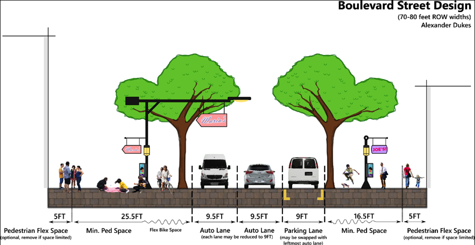
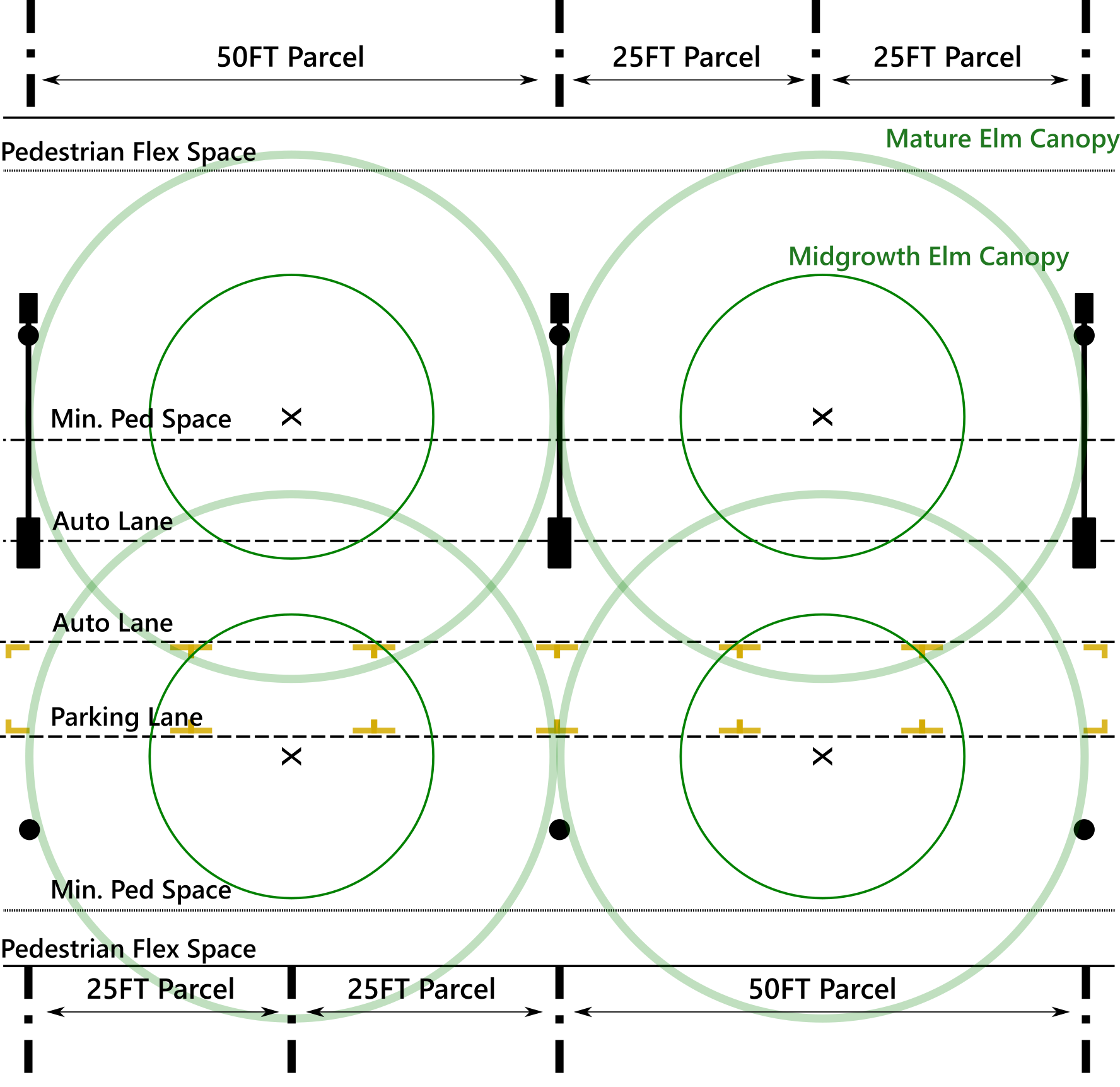
The first thing about this boulevard design most people will notice is that its pedestrian space feels exceptionally wide. This is due to the fact that most municipalities make the choice to prioritize auto traffic over pedestrian activity, and we have become culturally trained to dedicate most of the right of way to cars.
Auburn’s College Street, for instance, has a right of way width of 100 feet. In the past, pedestrians, horse-drawn wagons, and even cars (for a time) all shared the street simultaneously and spontaneously. Effectively, the 100 feet of College Street 100 years ago was likely either shared space or the pedestrian sidewalk. Today, the automobile roadway consumes 60 percent of College Street’s right of way with two driving lanes, two lanes of angled parking, and a left turn lane.
The boulevard street design for the mall site manages to commit 65 percent of its width to pedestrian space with less actual right of way to work with than College Street. This is done by doing away with turn lanes altogether, and having only one lane of parallel parking. With these auto-oriented features removed, much more space can be granted to the pedestrian.
Bike space also does its part to provide more pedestrian space. To accommodate cyclists on the boulevard, street trees and lamp posts/kiosks are spaced in such a way that they create a perceptive zone between them that should be relatively free of pedestrians. Cyclists, skateboarders, and Segways should largely hold to riding in this lane in-between the lamp posts and trees (as shown on the top image). The benefit of this bike lane’s informality is that it enables the entire pedestrian space to flex according to its immediate needs.
For example: A popular farm-stand vendor in the right of way might cause people to crowd slightly and spill into the informal bike lane. No big deal. For that specific moment, a cyclist might have to dismount their bike and walk through the crowd, or ride briefly with auto traffic. If the boulevard design used formal sidewalks and bike lanes and divided the two with a six-inch curb, the bike lane would be unable to flex with the immediate needs of the moment, and a valuable pedestrian experience would be harmed.
The sum result of all of this is that the remaining boulevard street space provides an enormous amount of room for pedestrians. The maximum 80 feet right of way is so vast that a shop can have a nine-foot expansion into the pavement on one side of the street, while another shop can have a four-foot expansion on the opposite side. In total, these expansions would take up 13 feet of space from pedestrians, and people would still have 39 feet of space to walk within. Additionally, the majority of street accessories (streetlights, public phones/info kiosks, trashcans, fire hydrants, etc.) would typically be located at lot lines to keep right of way free for lot expansion into the street. (Expansions from parcels into the right of way will be discussed in detail in a later article in this series.)
Finally, all of this pedestrian space would be sheltered by a sixty foot high vaulted canopy produced by fully mature Princeton Elms. The elms will gradually shade the entire streetscape as they grow taller and broader over the decades. Their purpose is not merely to appear beautiful (though they are), but also to shield pedestrians from the oppressive Alabama heat. Providing shade for pedestrians makes walking more comfortable, and therefore more common, and therefore improves community street life.
The Front Street
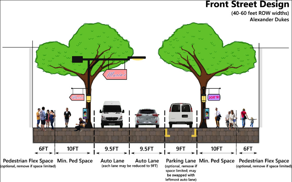
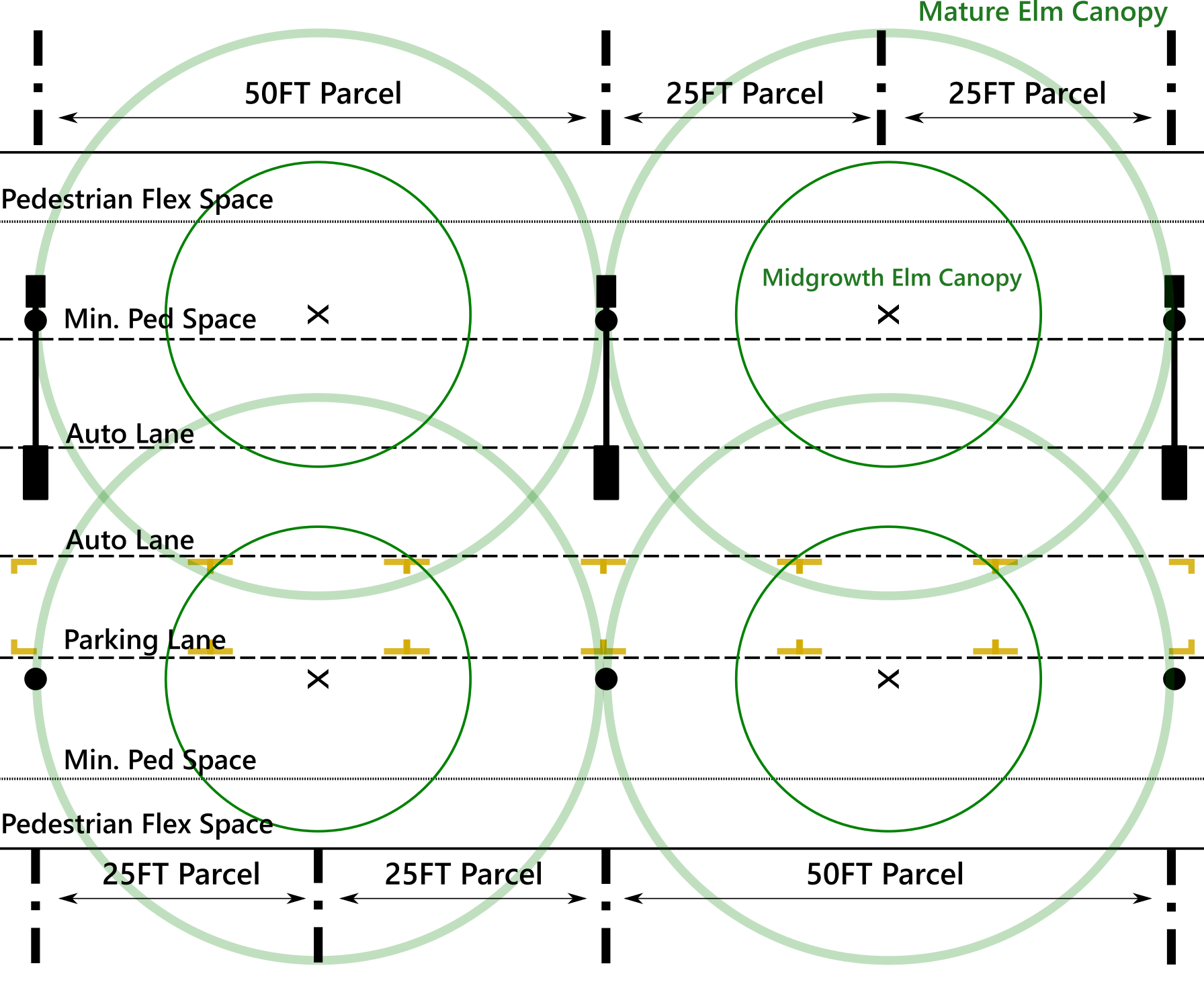
The front streets largely follow the same design paradigm established by the boulevard, except that the informal bike lane has been removed. Instead, street lamps and street trees are placed along the same line. This choice preserves a decent amount of space for pedestrians, but cyclists on these streets will either have to slow down within the pedestrian space or ride cooperatively with automobiles.
Front streets are intended to be calmer, bearing greater resemblance to a residential lane than a bustling boulevard. If you have a ground level residence on a front street, your porch or stoop should open to a space pleasant enough to serve as a kind of front yard. Yet, just because the front streets are calm and domestic does not mean they are inactive. Less noisy street activities like painting classes, flower kiosks, and outdoor dining may occur on them. (Precisely what land uses can occur on which streets will be discussed in a later article in this series.)
The Alley Street
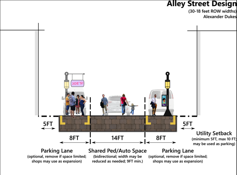
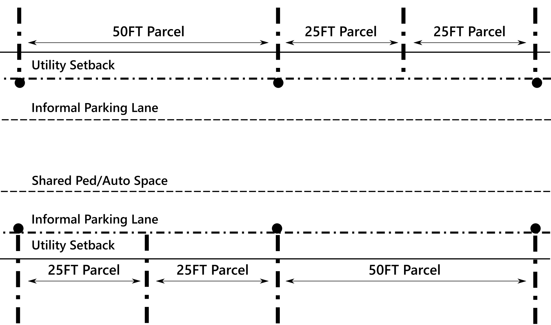
Rear alley streets are designed to be as flexible as possible. The first thing to understand about alleys is that while all buildings on boulevards and front streets must be built to the street, there is no such requirement for rear alleys. In fact, the foundation supported portion of buildings must be set back a minimum of five feet from an alley to keep utilitarian uses (trash cans, parking, electric meters, air conditioners, etc.) from cluttering up the alleyway. That being said, landowners can use the parking lane to expand out into the street with displays, stands, or structures that do not require a foundation- so long as their utility uses do not consume streetspace.
One problem readers may point out with this design is that in certain situations (like the one shown above) auto drivers might perceive the alleys as a wide open space to speed through. Please note that these street designs are only intended to show space allocations required for the street. Planners and civil engineers should add and remove certain elements according to circumstance. As long as the core concept of the design is retained, minor alterations are to be expected. In the case of the 30 foot alley shown above, a row of trees at every other lot line would likely improve the space. Also note that some alleys will be pedestrian only. (Those will be indicated in the final composite version of the full plan for the mall site at the end of the “A Town Well Planned” series.)
In closing, I would like to remind readers that neither Master Street Plans nor the Civic Development System they are a part of are intended to be dictatorial. Rather, these plans are meant to be developed in context and in consultation with the communities they affect. In the case of this article, before determining how the street will look in their town, civic planners should settle on an underlying theory to guide their street designs. In doing this, planners must ask a few questions: “What are our priorities within this limited right of way space? Are we prioritizing auto travelers over pedestrians? Do we really need a bike lane, or are wider sidewalks sufficiently safe? Should we have street trees?”
Such questions may seem simple at first glance, but they become frighteningly complex when you consider the context of specific streets, in specific neighborhoods, in specific municipalities. Each municipality and neighborhood is going to have different ideas about how to use their street space. Therefore, it is important that planners not only ask the aforementioned questions of themselves, but also pose these questions to the neighborhoods affected by the streets in question. In other words, planners need to determine what the “public will” for a street is. Take a look at my previous article, "Determining Public Will" for more ideas.
Read the next article in this series, "Hierarchical Zoning."


Alexander Dukes (Twitter | LinkedIn) has been a regular contributor for Strong Towns since 2016, and works as a Community Planner for the US Air Force in California. He is a graduate of Tuskegee University and Auburn University, with a Bachelor’s in Political Science and Master’s degrees in Community Planning and Public Administration. With this background, Alexander focuses his planning work on public policy and urban design for both military and civilian applications. Alexander's goal is to build sustainable human environments that provide all citizens with access to cohesive communities, affordable housing, meaningful employment, and beautiful places.